
First ascent Martino Baretti Elevation 3,333 m First ascender Martino Baretti | Easiest route for the southern ridge Prominence 339 m | |
 | ||
Listing Alpine mountains above 3000 m Similar Mont d'Ambin, Punta Galambra, Monte Ambin, Cima del Vallonetto, Aiguille de Scolette | ||
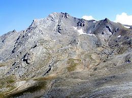
Punta Sommeiller (in Italian) or Pointe Sommeiller (in French) is a mountain of the Province of Turin, Italy and of Savoie, France. It lies in the Cottian Alps range. It has an elevation of 3,333 metres above sea level.
Contents
- Map of Punta Sommeiller 73500 Bramans France
- EtymologyEdit
- GeographyEdit
- Access to the summitEdit
- Mountain hutsEdit
- MapsEdit
- References
Map of Punta Sommeiller, 73500 Bramans, France
EtymologyEdit
The old name of the mountain was Rognosa di Galambra, which derived from the secondary valley of Galambra (a tributary of Dora Riparia). It was then renamed by the geologist Martino Baretti, author of the first documented ascent to the summit, in order to avoid confusions with two neighboring "Rognosa"s, Rognosa d'Etiache and Rognosa del Sestriere. The new name was chosen to honour Germain Sommeiller, the civil engineer which directed the construction of the Fréjus Rail Tunnel between Savoy and Piedmont.
GeographyEdit
In the French subdivision of western Alps it belongs to the Massif du Mont-Cenis while in the SOIUSA (International Standardized Mountain Subdivision of the Alps) it is part of the mountain group called "gruppo d'Ambin" (Italian) or "groupe d'Ambin" (French).
Administratively the mountain is divided between the Italian comunes of Bardonecchia (SW face) and Exilles (SE face) and the French commune of Bramans (N face).
A geodetic point of the Italian Military Geographic Institute is defined on the top of the mountain.
Access to the summitEdit
The easiest route for the summit starts from passo Settentrionale dei Fourneaux (3,159 m, which connects Exilles and Bardonecchia), then follows the south ridge of the mountain.