
Type Formation | ||
 | ||
Region San Gabriel Mountains,Los Angeles County, California | ||
The Punchbowl Formation is a sedimentary sandstone geologic formation in the northern San Gabriel Mountains, above the Antelope Valley in Los Angeles County, southern California.
Geology
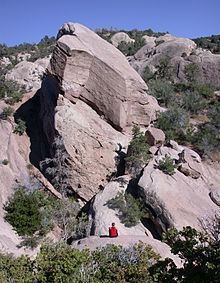
The formations sandstone strata are seen in the walls of the Devil's Punchbowl, a scenic gorge within the Devil's Punchbowl Natural Area, an L.A. County park within the Angeles National Forest. has folded and uplifted the formation in view. The Devil's Punchbowl is a large plunging sandstone syncline, where the edges of the formation have been folded upward, and the center has dipped. It was formed by the Punchbowl Fault, which is near the San Andreas Fault to the north.
The uplifted formation preserves fossils dating back to the Neogene period of the Cenozoic geologic era, formed during the lower Pliocene to upper Miocene Ages (~5-10 million years ago).
The Devil's Punchbowl drainage flows into Sandrock Creek, a tributary of Big Rock Creek, which disappears into the Mojave Desert.