 | ||
The puerto rico trench with dr uri ten brink nautilus live
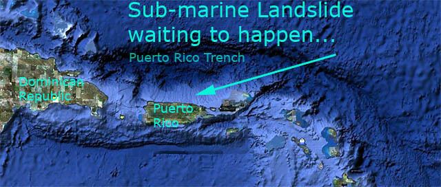
The Puerto Rico Trench is located on the boundary between the Caribbean Sea and the Atlantic Ocean. The oceanic trench is associated with a complex transition between the Lesser Antilles subduction zone to the south and the major transform fault zone or plate boundary, which extends west between Cuba and Hispaniola through the Cayman Trench to the coast of Central America. The trench is 800 kilometres (497 mi) long and has a maximum depth of 8,648 metres (28,373 ft) or 5.373 miles at Milwaukee Deep, which is the deepest point in the Atlantic Ocean and the deepest point not in the Pacific Ocean.
Contents
- The puerto rico trench with dr uri ten brink nautilus live
- Puerto rico trench dive animation 1080p
- Geology
- Public awareness
- Earthquake history
- References
Scientific studies have concluded that an earthquake occurring along this fault zone could generate a significant tsunami. The island of Puerto Rico which lies immediately to the south of the fault zone and the trench, suffered a destructive tsunami soon after the 1918 San Fermín earthquake.
Puerto rico trench dive animation 1080p
Geology
The Puerto Rico Trench is located at a boundary between two plates that pass each other along a transform boundary with only a small component of subduction. The Caribbean Plate is moving to the east while the North American Plate is moving to the west. The North American Plate is being subducted by the Caribbean Plate obliquely at the trench while to the southeast, the South American Plate is being more directly subducted along the Lesser Antilles subduction zone. This subduction zone explains the presence of active volcanoes over the southeastern part of the Caribbean Sea. Volcanic activity is frequent along the island arc southeast from Puerto Rico to the coast of South America.
Puerto Rico, the United States Virgin Islands, British Virgin Islands, and the Dominican Republic do not have active volcanoes; however, they are at risk from earthquakes and tsunamis. The Puerto Rico Trench is capable of producing earthquakes greater than magnitude 8.0.
Public awareness
Knowledge of the earthquake and tsunami risks has not been widespread among the general public of the islands located near the trench. Since 1988, the Puerto Rican Seismic Society has been trying to use the Puerto Rican media to inform people about a future earthquake that could result in a catastrophic tragedy.
Following the 2004 tsunami that affected more than forty countries in the Indian Ocean, many more people now fear the consequences that such an event would bring to the Caribbean. Local governments have begun emergency planning. In the case of Puerto Rico and the U.S. Virgin Islands, the United States government has been studying the problem for years. It is increasing its seismic investigations and developing tsunami warning systems.
Earthquake history
On 11 October 1918, the western coast of the island was hit by a major earthquake which caused a tsunami. The 1918 earthquake was caused by an old left-lateral strike-slip fault near the Mona Passage. In 1953, Santo Domingo, Dominican Republic, was affected by the Santo Domingo earthquake. The actual subduction zone (Puerto Rico Trench) has not ruptured in over 200 years, which is a major concern to geophysicists, as they believe it may be due for a major event.
Puerto Rico has always been an area of concern to earthquake experts because, apart from the 1918 episode, there are frequent tremors in and around the island, indicating activity. A 1981 tremor was felt across the island, while another in 1985 was felt in the towns of Cayey and Salinas.
"The January 13, 2014 M 6.4 earthquake north of Puerto Rico occurred as a result of oblique-thrust faulting. Preliminary faulting mechanisms for the event indicate it ruptured either a structure dipping shallowly to the south and striking approximately east-west, or a near-vertical structure striking northwest-southeast. At the location of this earthquake, the North America plate moves west-southwest with respect to the Caribbean plate at a velocity of approximately 20 mm/yr, and subducts beneath the Caribbean plate at the Puerto Rico Trench. The location, depth and mechanism of the earthquake are consistent with the event occurring on this subduction zone interface."
