
Country United States Founded July 22, 1851 Time zone AST (UTC-4) Local time Wednesday 9:45 AM | Demonym(s) Salinenses Zip code 00751 Population 30,981 (2011) | |
 | ||
Area code 787-537, 787-824, 787-853 Weather 28°C, Wind N at 5 km/h, 65% Humidity | ||
Salinas ([saˈlinas],Salines) is a municipality in the southern part of Puerto Rico located in the southern coast of the island, south of Aibonito and Cayey; southeast of Coamo, east of Santa Isabel; and west of Guayama. Salinas is spread over 7 wards and Salinas Pueblo (the downtown area and the administrative center of the city).
Contents
- Map of Salinas 00751 Puerto Rico
- History
- Geography
- Barrios
- Agriculture
- Business
- Industry
- Landmarks and places of interest
- Festivals and events
- Government
- Flag
- Coat of Arms
- References
Map of Salinas, 00751, Puerto Rico
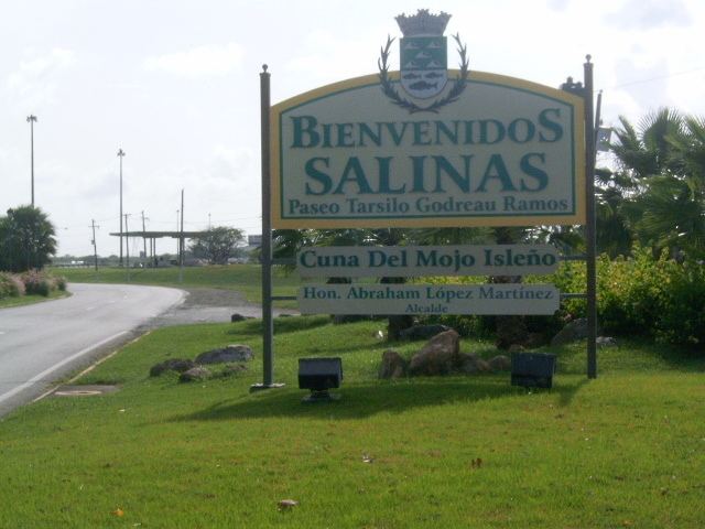
It has long been a fishing spot for Puerto Ricans, known for its beaches, fish variety and the birthplace of the famous "mojito isleño".
Although Salinas doesn't have any commercial airports, there is a military training area there. Camp Santiago, which is Puerto Rico National Guard training center. Army National Guard, Air National Guard, State Guard, U.S. Army ROTC, U.S. Army Reserve & the U.S. Army conduct military training at Camp Santiago.
Salinas is also home to Miss Universe 2006, Zuleyka Rivera.
History
Salinas was founded in July 22, 1841 by Don Agustín Colón Pacheco as Mayor, Don Jose Maria Cadavedo as Sargent of Arms, Don Juan Colon as Captain of the Civil Guard and five hacendados which were Don Antonio Semidey, Don Antonio Morelli, Don Francisco Secola, Don Julio Delannoy and Don Jose Antonio Torres.
Geography
Barrios
Agriculture
Business
Industry
Electrical and electronic machinery, plastics, sunglasses.
Landmarks and places of interest
Festivals and events
Government
All municipalities in Puerto Rico are administered by a mayor, elected every four years. Karilyn Bonilla Colón (of the Popular Democratic Party) was elected as mayor at the 2012 general election, succeeding Carlos Rodríguez Mateo.
The city belongs to the Puerto Rico Senatorial district VI, which is represented by two Senators. In 2012, Miguel Pereira Castillo and Angel M. Rodríguez were elected as District Senators.
Flag
On a green rectangular field, five white isosceles triangles equal in size, placed in the center of the flag and forming a row that covers the extent of the background. The green represents the land and the triangles hills of salt from which the name of the town is derived.
Coat of Arms
The shield uses the traditional colors of the town; green and silver. The salt knolls indicate in graphical form the name of the town: Salinas. The fish refer to the fishing. The sugar cane leaves that surround the shield, symbolize the sugar cane plantations.