
- elevation 7,930 ft (2,417 m) - average 70 cu ft/s (2 m/s) Discharge 1.982 m³/s Basin area 6,874 km² | - elevation 5,102 ft (1,555 m) Length 269 km Basin area 6,874 km² | |
 | ||
- max 17,800 cu ft/s (504 m/s) | ||
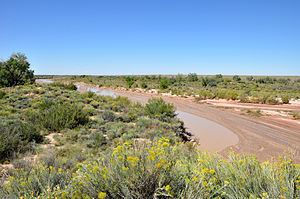
Rio puerco river and red rock mountain in navajo land usa
The Puerco River (Spanish): Rio Puerco) flows in northwestern New Mexico and northeastern Arizona, through arid terrain, including the Painted Desert.
Contents
- Rio puerco river and red rock mountain in navajo land usa
- Map of Puerco River Arizona USA
- NameEdit
- GeographyEdit
- CourseEdit
- DischargeEdit
- Water pollutionEdit
- Radioactive spillEdit
- References
Map of Puerco River, Arizona, USA
NameEdit
The Puerco River is sometimes called Rio Puerco of the West, to distinguish it from the Rio Puerco of the East that rises in the same vicinity but flows east to the Rio Grande.
Although the word Puerco means Pig It also used to mean dirty or filthy in Spanish, this usage in the SW United States is better translated as Dirty River or Muddy River due its high content of silth & mud.
GeographyEdit
The intermittent river is the main tributary of the Little Colorado River, which is a tributary of the Colorado River. It drains an area of about 2,654 square miles (6,870 km2) and is 167 miles (269 km) long. The river's average discharge is very low, less than 70 cubic feet per second (2.0 m3/s) in normal years, because its drainage basin is extremely dry. For most of the year, the Puerco River is a braided wash containing little or no water, although large flash floods can occur in downpours.
CourseEdit
The Puerco River headwaters are on the western slopes of the Continental Divide of the Americas, 0.5 miles (0.80 km) east of Hosta Butte, in McKinley County, New Mexico. It flows first north, and then west, through a wide and barren desert valley bordered by high rocky buttes and cliffs. It passes under Interstate 40, and receives the South Fork Puerco River from the right-south near Gallup. For most of its remaining course, I-40 and the former Atchison, Topeka and Santa Fe Railway (now the BNSF Railway) tracks follow the river's valley.
The Puerco River crosses into Apache County, Arizona. It flows by Houck, Sanders, and Chambers, and then flows through the middle of Petrified Forest National Park, where Lithodendron Wash enters from the left-north. The river then flows southwest to its confluence with the Little Colorado River, near the eastern side of Holbrook.
DischargeEdit
The United States Geological Survey (USGS) operates a Puerco River stream gauge 1 mile (1.6 km) southwest of Chambers in Arizona. The maximum discharge recorded by this gauge between 1971 and 2009 was 17,800 cubic feet per second (500 m3/s) on Sept. 30, 1971, and the minimum discharge was often zero, from a drainage basin of 2,156 square miles (5,580 km2).
Water pollutionEdit
Navajos in the Puerco River Valley have used surface waters in the Puerco River for livestock watering for decades.
From the 1950s through the early 1980s, the Puerco River ran almost continuously from being fed by mining wastewater, some untreated, from uranium mines upstream.
Radioactive spillEdit
The Church Rock uranium mill spill is one of the worst radioactive spills in U.S. history. On July 16, 1979, a tailings pond at the Church Rock uranium mill, owned by United Nuclear Corporation, breached its dam and 93 million gallons (350,000 m3) of radioactive, acidic uranium tailings solution flowed into the North Fork of the Puerco River. Approximately 1,100 short tons (1,000 t) of uranium mine waste contaminated 250 acres (100 ha) of land and up to 50 miles (80 km) of the Puerco River.