
City rights 1979 Time zone EET (UTC+2) Population 1,500 (2010) | Elevation 111 m (364 ft) Founded 4 February 1970 Local time Monday 10:34 AM | |
 | ||
Weather 7°C, Wind NW at 27 km/h, 65% Humidity Neighborhoods Urban area #3, Community IV, Urban area I, Urban area #2, Citywide center, Urban area #5 Points of interest Pripyat amusement park, Koleso obozreniya, Pripyat' | ||
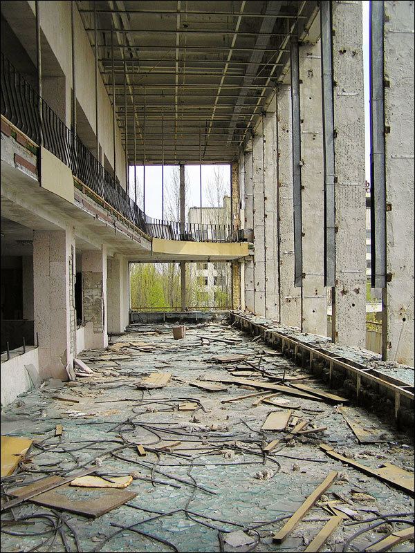
Pripyat (Ukrainian: При́п'ять, Prýp'jat′; Russian: При́пять, Prípyat′ Pronunciation) is a ghost town in northern Ukraine, near the border with Belarus.
Contents
- Map of Prypyat Kyivska oblast Ukraine
- 10 pripyat sports centre public pool lazurny azure and basket ball court
- Background
- Post Chernobyl years
- Infrastructure and statistics
- Safety
- Transport
- Personalities
- References
Map of Pryp'yat', Kyivs'ka oblast, Ukraine
Named after the nearby Pripyat River, Pripyat was founded on 4 February 1970, as the ninth nuclear city (a type of closed city) in the Soviet Union, to serve the nearby Chernobyl Nuclear Power Plant. It was officially proclaimed a city in 1979, and had grown to a population of 49,360 by the time it was evacuated, on the afternoon of April 27, 1986, the day after the Chernobyl disaster.
Though Pripyat is located within the administrative district of Ivankiv Raion, the abandoned city now has the status of city of oblast significance within the larger Kiev Oblast (province), being administered directly from Kiev. Pripyat is also supervised by Ukraine's Ministry of Emergencies, which manages activities for the entire Chernobyl Exclusion Zone.
10 pripyat sports centre public pool lazurny azure and basket ball court
Background
Access to Pripyat, unlike cities of military importance, was not restricted before the disaster as nuclear power stations were seen by the Soviet Union as safer than other types of power plants. Nuclear power stations were presented as being an achievement of Soviet engineering, where nuclear power was harnessed for peaceful projects. The slogan "peaceful atom" (Russian: мирный атом, mirnyy atom) was popular during those times. The original plan had been to build the plant only 25 km (16 mi) from Kiev, but the Ukrainian Academy of Sciences, among other bodies, expressed concern about it being too close to the city. As a result, the power station and Pripyat were built at their current locations, about 100 km (62 mi) from Kiev. After the disaster the city of Pripyat was evacuated in two days.
Post-Chernobyl years
In 1986 the city of Slavutych was constructed to replace Pripyat. After the city of Chernobyl, this is the second-largest city for accommodating power plant workers and scientists in the Commonwealth of Independent States (CIS).
One notable landmark often featured in photographs of the city and visible from aerial-imaging websites is the long-abandoned Ferris wheel located in the Pripyat amusement park. The Azure Swimming Pool and Avanhard Stadium are two other popular tourist sites.
Infrastructure and statistics
The following statistics are from January 1, 1986.
Safety
A natural concern is whether it is safe to visit Pripyat and the surroundings. The Zone of Alienation is considered relatively safe to visit, and several Ukrainian companies offer guided tours around the area. At present, radiation levels have dropped considerably, compared to the fatal levels of April 1986, due to the decay of the short-lived isotopes released during the accident. In most places within the city the level of radiation does not exceed an equivalent dose of 1 μSv (one microsievert) per hour.
Transport
The city was served by Yaniv station on the Chernihiv–Ovruch railway. It was an important passenger hub of the line and was located between the southern suburb of Pripyat and the village of Yaniv. An electric train terminus Semikhody, built in 1988 and located in front of the nuclear plant, is currently the only operating station near Pripyat connecting it to Slavutych.