
 | ||
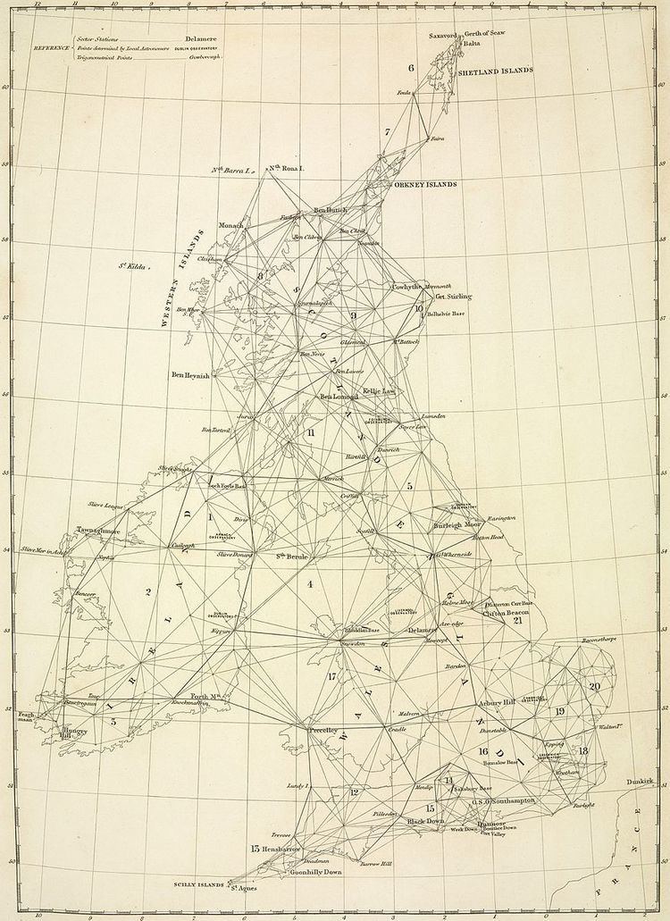
The Principal Triangulation of Britain was the first high precision trigonometric survey of the whole of Great Britain (including Ireland), carried out between 1791 and 1853 under the auspices of the Board of Ordnance. The aim of the survey was to establish precise geographical coordinates of almost 300 significant landmarks which could be used as the fixed points of local topographic surveys from which maps could be drawn. In addition there was a purely scientific aim in providing precise data for geodetic calculations such as the determination of the length of Meridian arcs and the Figure of the Earth. Such a survey had been proposed by William Roy (1726–1790) on his completion of the Anglo-French Survey but it was only after his death that the Board of Ordnance initiated the trigonometric survey, motivated by military considerations in a time of a threatened French invasion. Most of the work was carried out under the direction of Isaac Dalby, William Mudge and Thomas Frederick Colby, but the final synthesis and report (1858) was the work of Alexander Ross Clarke. The survey stood the test of time for almost one hundred years until the Retriangulation of Great Britain between 1935 and 1962.
Contents
History
In the aftermath of the Jacobite rising of 1745 it was recognised that there was a need for an accurate map of the Scottish Highlands and the necessary survey was initiated in 1747 by Lieutenant-Colonel David Watson, a Deputy Quartermaster-General of the Board of Ordnance. Watson employed William Roy as a civilian assistant to carry out the bulk of the work. Subsequently Roy, having enlisted in the army and having become a very competent surveyor, proposed (1763) a national survey which would be a plan for defence at a time when French invasions were threatened. The proposal was rejected on grounds of expense.
Roy continued to lobby for a survey and his ambitions were realised to a certain extent by an unexpected development. In 1783 the French Academy of Sciences claimed that the latitude and longitude differences between the Royal Observatory, Greenwich and the Paris Observatory were incorrect, and it was proposed (to the Royal Society) that the differences could be reconciled by high precision triangulation over the intervening terrain. The Royal Society agreed and, jointly with the Board of Ordnance, they invited Roy to oversee the project. (Main article; Anglo-French Survey (1784–1790).)
Roy's first task (1794) was to measure a base line between Hampton Poor House and King's Arbour on Hounslow Heath, a distance of just over 5 miles (8km). This was a painstaking process: three rods of about 20 ft. were supported on trestles and the ends aligned to an accuracy of a thousandth part of an inch. The first rod was then carried to the end of the third, an operation to be repeated 1370 times. The final measurement gave the length of the base as 27404.01 ft. (8352 metres).
For the subsequent triangulation Roy ordered a new theodolite from leading instrument-maker Jesse Ramsden. This Ramsden theodolite, delivered in 1787, for the first time divided angular scales accurately to within a second of arc. The theodolite was the largest ever constructed but, despite its massive size, it was carried from London to the Channel coast and employed on hills, steeples and a moveable tower. At each location the angles to other vertices of the triangulation mesh were measured many times, often at night time using newly devised lights. Finally the angle data was used to calculate the sides of the triangles by using spherical trigonometry.
The final results were inconclusive, for triangulation was inferior to the precision of astronomical measurements, but the survey paved the way for all future work in terms of high precision measurements of length and angle, together with the techniques of calculating on an ellipsoidal surface. In his final report, published posthumously, Roy once again pressed for the extension of the survey to the rest of Britain. His successors would oblige. As Master of the Board of Ordnance (from 1782), Charles Lennox, 3rd Duke of Richmond, viewed Roy's work with great interest, At the same time he was acutely aware that Britain, lacking a national survey, was falling behind the standards of many other European countries. Moreover the renewed threat of French invasion made him alarmed at the lack of accurate maps, particularly of the southern counties. The catalyst for action was the sudden availability of a new improved Ramsden theodolite which had been intended for the East India Company. The purchase of this instrument on 21 June 1791 by the Board is taken as the inauguration of the Ordnance Survey. The very next day Richmond appointed Isaac Dalby as its first employee, with a brief to extend Roy's survey.
Baseline measurement
The original base-line across Hounslow Heath was measured with deal rods and iron bars to be 27,404 ft. It was re-measured with 1,370 placements of glass tubes as 27,406 ft. This was corrected for temperature and mean sea level, and the value achieved an accuracy of 1 inch in 27,404 ft, which is 3 parts per million.
Corrections
During subsequent triangulation, errors due to atmospheric refraction, deflection of plumb-bobs, temperature, and the spherical nature of the earth (meaning there were more than 180 degrees in a triangle) were all allowed for.