
Area 21.27 km² Established March 30, 2009 | Address Las Cruces, NM 88007, USA Phone +1 575-525-4300 | |
 | ||
Website Prehistoric Trackways National Monument Hours Open today · Open 24 hoursSaturdayOpen 24 hoursSundayOpen 24 hoursMondayOpen 24 hoursTuesdayOpen 24 hoursWednesdayOpen 24 hoursThursdayOpen 24 hoursFridayOpen 24 hoursSuggest an edit Similar Basin and Range National, Berryessa Snow Mountain, Mesilla Valley Bosque S, Leasburg Dam State Park, Salinas Pueblo Missions | ||
Prehistoric trackways national monument
Prehistoric Trackways National Monument is the 100th national monument in The United States of America. The monument is located in the Robledo Mountains, near Las Cruces in the southern region of the U.S. state of New Mexico. The monument's fossilized features are on 5,255 acres (2,127 ha) of Bureau of Land Management administered land in Doña Ana County.
Contents
Discovery
Fossils
The Prehistoric Trackways National Monument site includes a major deposit of Paleozoic Era fossilized footprints in fossil mega-trackways of land animals, sea creatures, and insects. These are known as trace fossils or ichnofossils. There are also fossilized plants and petrified wood present. Much of the fossilized material originated during the Permian Period and is around 280 million years old.
Some of the animals who may have left tracks in the Robledo mountains include; Dimetrodon, Eryops, Edaphosaurus, and multiple other pelycosaurs. There are at least 13 major trace fossils found at the monument and include Selenichnites (sel-EEN-ick-NIGHT eez) or moon-shaped trace, Kouphichnium (koof-ICK-nee-um) or light trace, Palmichnium (pal-ICK-nee-um) or palm [frond] trace, Octopodichnus (oct-toe-pod-ICK-nuss) or eight-footed trace, Lithographus (lith-oh-GRAFF-us) or rock writing, Tonanoxichnus (tong-a-nox-ICK-nuss) or Tonganoxie [Kansas] trace, Augerinoichnus (aw-gurr-EE-no-ICK-nuss) or Augerino trace, Undichna (und-ICK-nuh) or wave-shaped trace, Serpentichnus (serpent-ICK-nuss) or snake-like trace, Batrachichnus (baa-track ICK-nuss) or frog trace, Dromopus (dro-MOE-puss) or running foot, and Dimetropus (die-MEET-row puss) or Dimetrodon foot.
Trackways can be difficult for the general public to find at the monument and few facilities have yet been developed. Many of the slabs pulled out by Jerry MacDonald are housed at the New Mexico Museum of Natural History and Science, although they are not on display at this time. Guided hikes are offered by BLM interpretive staff periodically.
There are plenty of marine invertebrate fossils to be found in the monument; they include brachiopods, gastropods, cephalopods, bivalves, and echinoderms.
Discovery
In situ Paleozoic Era tracks were discovered on June 6, 1987 by Jerry Paul MacDonald. Scattered footprints had been found in the Robledo’s for almost fifty years prior to Jerry MacDonald starting his search. He used the recollections of local hikers, quarrymen, and fossil hunters to concentrate his search. This initial site was named the “Discovery Site”. It is one of the best places in the monument for visitors to see fossilized tracks. Jerry MacDonald excavated three long trackways, carrying over 2500 slabs out from the site on his back. The majority of the slabs are housed in the New Mexico Museum of Natural History and Science in the Jerry MacDonald Paleozoic Trackways Collection. Two other continuous trackways are held in the Carnegie Museum and Smithsonian.
Monument designation
Prehistoric Trackways National Monument was sponsored by Senators Jeff Bingaman (D-NM) and Pete Domenici (R-NM) and was part of the National Landscape Conservation System of the United States of America under the Omnibus Public Land Management Act, signed into law on March 30, 2009. This is first National Monument established under the Barack Obama administration, and the fourth established in 2009. At the time of its establishment, it was the 100th active National Monument in the United States.
Recreation
The Bureau of Land Management is in the process of writing a resource management plan for the monument to be completed in 2012. In the meantime, there are no developed hiking and equestrian trails, and only one interpretive sign. Roads are not maintained and there are no facilities. There are OHV and mountain bike trails, which are rugged and require appropriate skills and equipment.
Geology
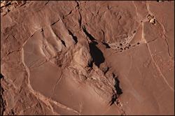
The monument lies along the western portion of the Rio Grande rift and is within part of the Robledo Mountains. It is made up of Cenozoic and Paleozoic (Hueco Group) sediments. The Hueco Group is early Permian strata. Most of the monument is Permian and would have been under water or along the coast of what was once the Hueco Seaway. The tracks can be found in the red rock which is called the abo red beds.
Flora and fauna
The monument is in the northern tip of the Chihuahuan Desert. Some examples of plants within the monument are ocotillo, mesquite, creosote bush, prickly-pear cactus, Torrey yucca, barrel cactus, sotol, agave and snakeweed. A few of the animals that you may see are mule deer, rattlesnakes, desert cottontail, many species of lizards, and several species of birds.
Climate
On average the coolest month in the monument is January with an average high of 57 °F (14 °C), the hottest month is June with an average high temperature of 94 °F (34 °C), and the wettest month is August with about 2.52 inches (64 mm) of rain fall.