
Municipality Porto Novo | Local time Friday 4:21 PM | |
 | ||
Weather 24°C, Wind E at 35 km/h, 57% Humidity | ||
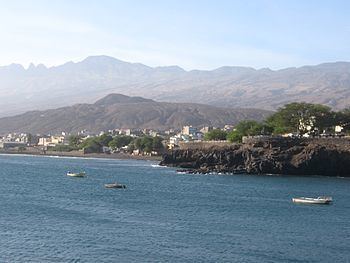
Porto Novo is a town in the island of Santo Antão, in Cape Verde. It constitutes the seat of the Porto Novo municipality. It is situated on the south coast of the island, opposite the island São Vicente and is the seat of São João Batista parish. At the 2010 census, the town had 9,310 inhabitants, which makes it the most populous town of the island and one of the most populated places in the country.
Contents
Map of Porto Novo, Cape Verde
The city was once called Carvoeiros, and it gradually became the largest urban settlement of the island, and has the main harbor of the island for commercial exchanges, recently, the port went under expansion. Numerous streams with each no longer than 300 to 400 meters distant in the southern part dominate the vicinity as the area covers to the eastern municipal boundary. Once featured three streams, the today's urban area stretches through five and six dry streams.
In the 1960s, the Estrada da Corda opened and links Porto Novo and Ribeira through the valley and ridges and the eastern crater with curves dominating much of the length, most of the road are treacherous. Since 2009, the Porto Novo-Janela Road forming a part of what became the Ribeira Grande-Paul-Porto Novo Road or the East Island (Estrada Litoral) Road runs through the island's easternmost point completed bypassing the difficult Estrada da Corda, first constructed in 2004 and completed five years later, one dangerous dirt track links the middle interior villages. In around 2012, about a 7 kilometer stretch of the Porto Novo-Norte/Topo da Coroa was widened to four lanes up to the newly opened pozzolano brick plant.
Urban sprawl spreaded slowly in town mainly into a square shape in around 2004, and is slightly lesser than a square shape as of 2016.
After Espargos surpassed the town's population in the 2000s, it was the fourth most populated place, also Assomada's population surpassed Porto Novo's and made it the fifth most populated place.
Panoramic views includes the island of São Vicente in the southeast and the surrounding mountains of the island in the west and the north.
Subdivisions
The city are divided into neighborhoods and sections including:
Sports
Clubs plays in the Santo Antão South Zone which covers the whole municipality. The football (soccer) clubs only based in the town are:
All clubs play at Estádio Municipal do Porto Novo located on the main road with the west of the island 1 km from the center, prior to 2009, clubs played at the small stadium named Amílcar Cabral which was southwest of the city some 200 meters south of the main road. Also basketball, volleyball and recently futsal clubs are also played in the city.
Climate
As it is located in an desertlike and arid landscape, its annual rainfall is 191 millimeters making it the driest on the island, the wettest month is September measuring 86 mm and the driest month are without any precipitation between April and July. Temperatures ranges from 20 to 27 °C (68–81 °F) making it the highest in the island as it is in a low-lying area.