
Time zone Central (CST) (UTC-6) Population 10,183 (2013) | State Wisconsin Elevation 794 ft (242 m) Area code(s) 608 Local time Friday 8:51 AM | |
 | ||
Weather 6°C, Wind E at 5 km/h, 86% Humidity Points of interest Cascade Mountain, Portage WW II History M, Museum At the Portage, Old Indian Agency House | ||
Portage is a city in and the county seat of Columbia County, Wisconsin, United States. The population was 10,662 at the 2010 census making it the largest city in Columbia County. The city is part of the Madison Metropolitan Statistical Area.
Contents
- Map of Portage WI 53901 USA
- How to say or pronounce usa cities portage wisconsin
- History
- Historic sites
- Geography
- Cityscape
- 2010 census
- 2000 census
- Education
- Corrections
- Major highways
- Rail
- Intercity Bus
- Airport
- References
Map of Portage, WI 53901, USA
Portage was named for the Fox-Wisconsin Waterway, a portage between the Fox River and the Wisconsin River, which was recognized by Jacques Marquette and Louis Joliet during their discovery of a route to the Mississippi River in 1673. The city's slogan is "Where the North Begins."
How to say or pronounce usa cities portage wisconsin
History
The Native American tribes that once lived here, and later the European traders and settlers, took advantage of the lowlands between the Fox and Wisconsin Rivers as a natural "portage". In May 1673, Jacques Marquette joined the expedition of Louis Jolliet, a French-Canadian explorer, to find the Mississippi River. They departed from St. Ignace on May 17, with two canoes and five voyageurs of French-Indian ancestry (Métis).[3] They followed Lake Michigan to Green Bay and up the Fox River, nearly to its headwaters. From there, they were told to portage their canoes a distance of slightly less than two miles through marsh and oak plains to the Wisconsin River. Later, French fur traders described the place as "le portage", which eventually lent itself to the name of the community. As a portage, this community developed as a center of commerce and trade; later, a canal was constructed to facilitate this trade. When the railroads came through, the community continued in this role.
Portage emerged at this place because of its unique position along the one and a half mile strip of marshy floodplain between the Fox and Wisconsin Rivers. By the end of the 17th century, the Fox-Wisconsin waterway, linked at The Portage, served as the major fur trade thoroughfare between Green Bay and Prairie du Chien. It was not until the 1780s and 1790s that traders built their posts and warehouses at each end of The Portage. In the early 19th century Portage was primarily populated by Métis. In 1828, the federal government recognized the strategic economic importance of The Portage and built Fort Winnebago at the Fox River end. After 15 years of controversy, Winnebago settlement (now Portage) won the county seat in 1851. The community incorporated as Portage City in 1854.
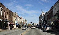
The Portage business district lies along a hill that overlooks the Portage Canal. The buildings now in the city's downtown were once part of a bustling, urban commercial center serving a large region across north central Wisconsin. The building of the city paralleled its commercial prominence between the end of the American Civil War and the second decade of the 20th century.
Historic sites
Geography
Portage lies in the Wisconsin River valley. The city is surrounded by prairies and grasslands. Approximately three miles (5 km) west of the city are the Baraboo bluffs. According to the United States Census Bureau, the city has a total area of 9.62 square miles (24.92 km2), of which, 8.82 square miles (22.84 km2) is land and 0.80 square miles (2.07 km2) is water. The location of the town at the split of the Wisconsin and Fox river is what gives it the name "Portage", which means carrying a boat of its cargo between two navigable waters.
Cityscape
When Portage was first established, the streets were laid out on a traditional grid system. Today, the streets of the outlying city are contorted as a result of the many marshes and lowlands that run through much of Columbia County. The northern side of the city thus looks different from the central city, with the organized grid street system giving way to a more suburban streetscape with a lower housing density.
The city has two commercial areas. One is the downtown historic district, which features several small boutique shops and restaurants; the other is the Northridge commercial area that features big box stores. In the summer of 2007, the Portage Canal was cleaned up and now features a bike path that runs alongside part of it. In the summer of 2008, the main downtown street was redone. Historical landmarks of the city include the Museum at the Portage, the Indian Agency house, and the Surgeons Quarters.
2010 census
As of the census of 2010, there were 10,324 people, 4,060 households, and 2,349 families residing in the city. The population density was 1,170.5 inhabitants per square mile (451.9/km2). There were 4,493 housing units at an average density of 509.4 per square mile (196.7/km2). The racial makeup of the city was 90.9% White, 5.0% African American, 0.9% Native American, 0.8% Asian, 0.7% from other races, and 1.6% from two or more races. Hispanic or Latino of any race were 4.0% of the population.
There were 4,060 households of which 31.0% had children under the age of 18 living with them, 40.5% were married couples living together, 11.9% had a female householder with no husband present, 5.4% had a male householder with no wife present, and 42.1% were non-families. 34.8% of all households were made up of individuals and 14.1% had someone living alone who was 65 years of age or older. The average household size was 2.27 and the average family size was 2.90.
The median age in the city was 37.2 years. 22.1% of residents were under the age of 18; 8.6% were between the ages of 18 and 24; 30.6% were from 25 to 44; 24.8% were from 45 to 64; and 13.9% were 65 years of age or older. The gender makeup of the city was 53.7% male and 46.3% female.
2000 census
As of the census of 2000, there were 9,728 people, 3,770 households, and 2,228 families residing in the city. The population density was 1,172.9 people per square mile (453.1/km²). There were 3,970 housing units at an average density of 478.7 per square mile (184.9/km²). The racial makeup of the city was 92.76% White, 3.90% African American, 0.51% Native American, 0.71% Asian, 0.05% Pacific Islander, 0.85% from other races, and 1.21% from two or more races. Hispanic or Latino of any race were 3.39% of the population.
There were 3,770 households out of which 30.1% had children under the age of 18 living with them, 44.5% were married couples living together, 10.7% had a female householder with no husband present, and 40.9% were non-families. 34.5% of all households were made up of individuals and 14.4% had someone living alone who was 65 years of age or older. The average household size was 2.30 and the average family size was 2.96.
In the city, the population was spread out with 23.3% under the age of 18, 10.6% from 18 to 24, 31.7% from 25 to 44, 19.3% from 45 to 64, and 15.2% who were 65 years of age or older. The median age was 36 years. For every 100 females there were 106.1 males. For every 100 females age 18 and over, there were 108.7 males.
The median income for a household in the city was $35,815, and the median income for a family was $44,804. Males had a median income of $33,158 versus $23,478 for females. The per capita income for the city was $18,039. About 4.6% of families and 7.2% of the population were below the poverty line, including 7.5% of those under age 18 and 7.8% of those age 65 or over.
Education
Portage Community School District serves Portage.
Portage High School (Wisconsin) was recently upgraded to a larger building, with the older high school building now housing the Wayne E. Bartels Middle School. Portage has three elementary schools: John Muir, Woodridge, and Rusch. Three rural elementary schools serve three of the towns in Columbia County: Lewiston, Fort Winnebago, and Caledonia. There are also two private schools: St. John's Lutheran and St. Mary's Catholic Schools. The Madison Area Technical College, also has a campus located in Portage.
Corrections
Wisconsin Department of Corrections operates the Columbia Correctional Institution.
Major highways
Three interstate highways, Interstate 94, Interstate 90, and Interstate 39 run past Portage, giving the city a 30-minute commute to Madison and 15-minute commute to Wisconsin Dells. The city also lies only a few hours from Milwaukee, Chicago, and Minneapolis/ Saint Paul, Minnesota.
Rail
Portage is served by Amtrak's Empire Builder between Chicago and Seattle, with a train stopping there in each direction every day.
Intercity Bus
Portage is served by intercity bus from Milwaukee via Madison and to Wisconsin Rapids via Stevens Point, with a bus stopping in each direction daily at the Portage station.