
- land 5.5 sq mi (14 km) Area 22.01 km² | - summer (DST) CDT (UTC-5) Area code 504 | |
 | ||
- water 3.0 sq mi (8 km), 35.29% Neighborhoods Fosters Canal, Home Place, Diamond | ||
Port Sulphur is a census-designated place (CDP) on the West Bank of the Mississippi River in Plaquemines Parish, Louisiana, United States. The population was 1,760 at the 2010 census.
Contents
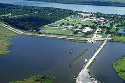
Map of Port Sulphur, LA, USA
The name Port Sulphur derives from the Freeport Sulphur Company in the early 1930s, when it set up logistics, refining, storage and shipping operations to support its Frasch Process sulphur mine at Lake Grande Ecaille, located 10 miles west of the town in the nearby marsh. The Grande Ecaille mine was the largest sulphur deposit in the world when it began operation in 1933, and remained in production until 1978. Over time, as other discoveries were made, The Freeport Sulphur Company also used the Port Sulphur facility to support their other Frasch Process sulphur mines located at Garden Island Bay, LA; Lake Pelto, LA; Caillou Island, LA; a land based mine at Chacahoula, LA; The first offshore sulphur mines at Grand Isle, LA and Caminada Pass, LA; and a large operation 50 miles offshore from the Mississippi River Delta in 300 feet of water, at Main Pass Block 299 in the Gulf of Mexico. The facility was also used to process and ship recovered sulphur obtained by oil and gas refining. The terminal was able to filter and store liquid hot molten sulphur in large insulated heated tanks, and "vat" liquid sulphur into acres of long term dry storage by forming blocks of bright yellow sulphur by spraying molten sulphur into metal forms on the ground and allowing to cool. The site is valuable because of its proximity to sulphur producing areas near the Gulf of Mexico, its docking sites along the Mississippi River and back bay marsh.
History
Port Sulphur was originally a typical company town, with its residents and civic life closely tied to the Freeport Sulphur Company. As time went by,the company divested itself of much of the town property and governance, it became more of a regular town with private individual land ownership. As the number of employees at the site dwindled, the Freeport Company became less important in everyday life and economic activity. At some point in time, most of the company-owned land not necessary for the sulphur operation was transferred to Plaquemines Parish or sold to private owners. The economic fortunes of the Freeport Sulphur Company declined during the 1980s and 1990s, resulting from its merger with McMoRan Exploration, an oil and gas company that neglected the sulphur operations. In the early 2000s Freeport Sulphur shut down operations, as the price of sulphur dropped too low because large amounts of sulphur recovered during petroleum refining and from Canadian natural gas exploration were dumped on the international sulphur market. With inexpensive recovered sulphur in large supply, the large scale and expensive Frasch Process sulphur mining and storage operations proved to be uneconomical and were discontinued. The Freeport-McMoRan Port Sulphur facility was closed and sold. Hurricane Katrina destroyed much of what was left of the sulphur facility in August 2005, with a few buildings remaining. With the closing of Freeport-McMoRan Sulphur, the town has been seeking another economic identity.
The large brick Plaquemines Parish Government building located on LA.HWY 23 in town next to the former Freeport property was originally the Freeport Sulphur Company administration building. The Port Sulphur school and other buildings located around the Civic Drive area were originally located on company property and are oriented towards the former Freeport Property. Much of the original town buildings were sold or removed, and much of the original town site sits mostly vacant empty land, with a large stand of oak trees on the former Freeport Property next to the Plaquemines Government building. An historical marker about Port Sulphur is located in front of the Government Building. The golf course land located on LA.HWY 23, just south of the former Freeport property, was originally a neighborhood of the company townsite. The land was later donated to the Plaquemines Parish Government.
The town began to struggle economically after Freeport Sulphur Mine ended its business in the town.
The town is 8 feet (2.4 m) above sea level and had not flooded during Hurricane Betsy nor Hurricane Camille. Before Hurricane Katrina and Hurricane Rita about 3,000 people lived in Port Sulphur. Nevertheless, in Hurricane Katrina, the federal levees failed and around 22 feet (6.7 m) of water engulfed the town. Almost all single family homes in the town were destroyed, many of which were moved off their foundation as many as 100 feet. In the months following Katrina, some residents moved back to Port Sulphur in trailers and modular homes provided by FEMA. But many residents relocated to other parts of Louisiana, the Southeast, and Texas.
By November 2006, in the post-Hurricane Katrina period, the post office and several businesses had reopened, and Highway 23 had some street lights added. By December 2007 there were about 1,500 residents of Port Sulphur and the majority of the small businesses resumed operations. Due to the usage of modular buildings and trailers in the period, Jeré Longman described it as "a feel of impermanence and uncertainty."
Geography
Port Sulphur is located at 29°29′40″N 89°42′45″W (29.494496, -89.712383).
According to the United States Census Bureau, the CDP has a total area of 8.5 square miles (22 km2), of which, 5.5 square miles (14 km2) of it is land and 3.0 square miles (7.8 km2) of it (35.29%) is water.
Demographics
As of the census of 2000, there were 3,115 people, 1,055 households, and 796 families residing in the CDP. The population density was 514.1 people per square mile (198.5/km²). There were 1,222 housing units at an average density of 201.7 per square mile (77.9/km²). The racial makeup of the CDP was 45.33% White, 44.43% African American, 7.03% Native American, 0.61% Asian, 0.03% Pacific Islander, 0.90% from other races, and 1.67% from two or more races. Hispanic or Latino of any race were 0.96% of the population.
There were 1,055 households out of which 37.3% had children under the age of 18 living with them, 49.8% were married couples living together, 20.0% had a female householder with no husband present, and 24.5% were non-families. 20.8% of all households were made up of individuals and 9.1% had someone living alone who was 65 years of age or older. The average household size was 2.93 and the average family size was 3.43.
In the CDP, the population was spread out with 30.8% under the age of 18, 10.1% from 18 to 24, 26.3% from 25 to 44, 22.2% from 45 to 64, and 10.6% who were 65 years of age or older. The median age was 33 years. For every 100 females there were 93.6 males. For every 100 females age 18 and over, there were 90.1 males.
The median income for a household in the CDP was $30,188, and the median income for a family was $33,021. Males had a median income of $29,609 versus $23,194 for females. The per capita income for the CDP was $13,553. About 20.5% of families and 22.2% of the population were below the poverty line, including 25.7% of those under age 18 and 22.4% of those age 65 or over.
Education
Plaquemines Parish School Board operates the public schools of the parish.
It is served by South Plaquemines Elementary School in Port Sulphur and South Plaquemines High School in Buras.
Prior to 2005 Port Sulphur High School (PK-12) served the community, but Hurricane Katrina damaged the original building.