
Country United States Time zone Central (CST) (UTC-6) Elevation 0 cm Population 945 (2010) | GNIS feature ID 558181 Local time Monday 6:15 PM Area code 504 | |
 | ||
Weather 20°C, Wind SE at 16 km/h, 86% Humidity Area 6.081 km² (5.957 km² Land / 2.714 km² Water) | ||
Buras is a census-designated place (CDP) in Plaquemines Parish, Louisiana, United States. Its population was 945 as of the 2010 census. Prior to the 2010 census, Buras was considered to be part of the Buras-Triumph CDP.
Contents
Map of Buras, LA 70041, USA
History
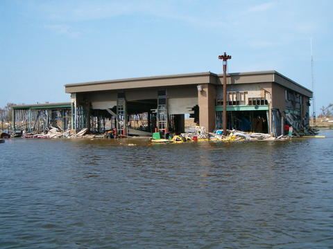
In November 2006 Jeré Longman of The New York Times wrote that "almost no evidence of recovery exists" in the post-Hurricane Katrin period. In December 2007 Logman reported that there was still "little sign of recovery" in Buras.
Demographics
In the pre-Katrina period (before 2005) Buras had about 30-40 Cambodian shrimpers. In the post-Hurricane period Brenda Kap, quoted in The New York Times, stated most of them had returned.
Education
Plaquemines Parish School Board operates the public schools of the parish.
It is served by South Plaquemines High School in Buras.
Prior to 2005 Buras Middle School (grades 6-8) and Buras High School (grades PK-5 and 9-12) served the community, but Hurricane Katrina damaged the buildings. In the immediate post-Katrina period no new campuses opened in Buras, leading some residents to feel that the community may further erode. The permanent school building of South Plaquemines High was established on the site of the former Buras Middle School, while faculty residences were placed on the property of the former Buras High School.