
OS grid reference SW971805 Post town PORT ISAAC Dialling code 01208 | Sovereign state United Kingdom Postcode district PL29 | |
 | ||
North cornwall coastal walk doc martin port isaac from port quin round
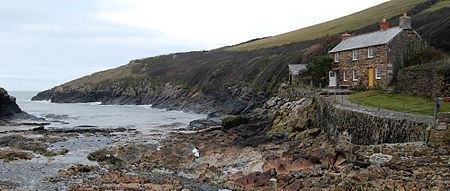
Port Quin (Cornish: Porth Gwynn, meaning white cove) grid reference SW971805 is a small cove and hamlet between Port Isaac and Polzeath in north Cornwall, England, UK.
Contents
- North cornwall coastal walk doc martin port isaac from port quin round
- Map of Port Quin Port Isaac UK
- Cornwall sea kayaking port quin to rumps point
- Geography
- History
- Present day
- References
Map of Port Quin, Port Isaac, UK
Cornwall sea kayaking port quin to rumps point
Geography
Facing the Atlantic Ocean, the narrow rocky inlet of Port Quin provides a naturally sheltered harbour for sea-going vessels. The cove gives its name to Port Quin Bay, a 2.5 mi (4.0 km) stretch of coast that extends from Kellan Head to The Rumps.
Port Quin lies within the Cornwall Area of Outstanding Natural Beauty (AONB). Almost a third of Cornwall has AONB designation, with the same status and protection as a National Park.
History
The name of the village is believed to come from the Cornish words "Porth" (harbour) and "gwynn" (white). Its earliest mention is when Laurence de Porquin took his name from the village in 1327.
During the medieval period, boats from Port Quin often sailed to Wales trading coal, manure, antimony, lead and building ashlar. The cove was from where granite from Lundy Island - used to build the tower of the parish church at St Endellion - was unloaded. The local economy was based primarily upon the pilchard season that operated from August to December. Fresh catches were placed in several large drying sheds in the village before being transported for sale. Farming and small tin mines were also important sources of revenue.
The size of the remaining fish cellars indicates that Port Quin was once a prosperous village. But by 1841 it was entering decline, a census recorded it had a population of 94 people and 23 houses. The community was slowly moving to neighbouring villages because of poor pilchard and herring seasons and the closure of local mines. Many emigrated (via Padstow) to Canada. As Port Quin dwindled to the size of a hamlet, its demise gave rise to the local legend of disaster at sea. It states that one Sunday - breaking the Sabbath - all the men of village put to sea but were lost in a great storm that destroyed the entire fishing fleet.
In February 1700 the East Indian ship Thornton was wrecked at Port Quin.
On the south-west side of the inlet is Doyden Point, on which is situated Doyden Castle, a castellated folly built about 1830 by a Samuel Symons, a late Regency bon viveur from Wadebridge.
Present day
The harbour is surrounded by 3 local farms Roscarrock, Trevigo and Scarrabine all run by local families. some of Port Quin and a few small fields around the hamlet are owned by the National Trust for Places of Historic Interest or Natural Beauty; the Trust rents out several of the stone cottages as self-catering holiday accommodation. The South West Coast Path closely follows the coastline of the inlet. Port Quin is popular with walkers and kayakers and there is a small car park, which during the Summer season has a small mobile vintage Cafe, on the lane which leads from Port Quin to the village of Trelights. There is a sea kayaking company based in the harbour called Cornish Coast adventures that runs tours between Easter and October and explores the old Antimony mines and the local coastline.
In 2011 Doyden Castle was used as "Pentire Castle" in the ITV series Doc Martin .