
Population 599 (2006 census) LGA(s) Corangamite Shire Mean max temp Mean min temp Local time Friday 7:51 PM | Postcode(s) 3269 Postal code 3269 | |
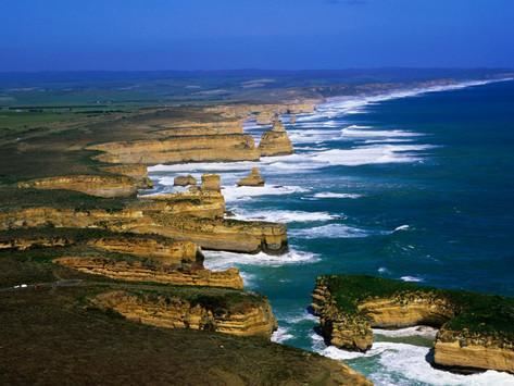 | ||
Weather 18°C, Wind E at 10 km/h, 81% Humidity Points of interest Port Campbell National, Loch Ard Gorge, The Twelve Apostles, London Arch, Twelve Apostles Marine N | ||
Travelers choice port campbell national park places to travel in australia
Port Campbell /pɔːt ˈkæmbəl/ is a coastal town in Victoria, Australia. The town is on the Great Ocean Road, west of the Twelve Apostles, in the Shire of Corangamite. At the 2006 census, Port Campbell had a population of 599.
Contents
- Travelers choice port campbell national park places to travel in australia
- Map of Port Campbell VIC 3269 Australia
- History
- References
Map of Port Campbell VIC 3269, Australia
History
The town was settled in the 1870s, with the first wharf being built in 1880. Port Campbell Post Office opened on 19 March 1874. It was renamed Port Campbell West in 1881 when a new Port Campbell office opened near the wharf. At the 2001 census, Port Campbell had a population of 372. At the 2006 census, Port Campbell had a population of 599. At the 2011 census, Port Campbell had a population of 618.
Port Campbell is now a popular tourist destination for visiting the The Twelve Apostles, located 12 kilometres to the east of the town and the Port Campbell National Park, as well as maintaining a small crayfishing community.