
OS grid reference SJ270420 Maintained by Canal & River Trust Height 38 m Bridge type Aqueduct | Heritage status Grade 1 Construction started 1795 | |
 | ||
Hours Open today · Open 24 hoursThursdayOpen 24 hoursFridayOpen 24 hoursSaturdayOpen 24 hoursSundayOpen 24 hoursMondayOpen 24 hoursTuesdayOpen 24 hoursWednesdayOpen 24 hoursSuggest an edit Similar Llangollen Canal, Navigable aqueduct, Erddig, Horseshoe Falls, Chirk Castle Profiles | ||
The mighty pontcysyllte aqueduct two boat crossings
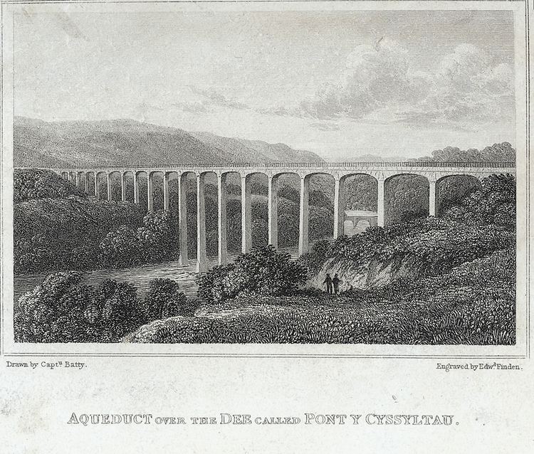
The Pontcysyllte Aqueduct ([ˌpɔntkəˈsəɬtɛ], full name in Welsh: Traphont Ddŵr Pontcysyllte) is a navigable aqueduct that carries the Llangollen Canal over the valley of the River Dee in Wrexham County Borough in north east Wales. Completed in 1805, it is the oldest and longest navigable aqueduct in Great Britain and highest in the world, a Grade I Listed Building and a World Heritage Site. The viaduct carries a water passage for a single canal narrow boat as well as a towpath for pedestrians, and is now a popular tourist excursion; boat trips cross the viaduct and return.
Contents
- The mighty pontcysyllte aqueduct two boat crossings
- Walking and barging the pontcysyllte aqueduct llangollen canal
- History
- Structure
- World Heritage Site
- Wildlife
- References
When the bridge was built, it linked the villages of Froncysyllte, at the southern end of the bridge in the Cysyllte township of Llangollen parish (from where it takes its name), and Trevor (Trefor in Welsh), at the northern end of the bridge in the Trefor Isaf township, also of Llangollen parish. The area was later transferred to Wrexham County Borough following local government reorganisation.
The name Pontcysyllte is in the Welsh language and means "Cysyllte Bridge". The township of Cysyllte existed for centuries before the bridge was built.
For most of its history, the aqueduct was known as Pont y Cysyllte ("Bridge of Cysyllte"). Other translations such as "Bridge of the Junction" or "The Bridge that links" are modern, derived from the word cysylltau (plural of cyswllt) which means connections or links. However that does not preclude the possibility that the original name of the township meant "connections".
There is a nearby road bridge called Cysylltau Bridge or Pont Cysylltau.
Walking and barging the pontcysyllte aqueduct llangollen canal
History
The aqueduct was built by Thomas Telford and William Jessop. It is 336 yd (307 m) long, 4 yd (3.7 m) wide and 5.25 ft (1.60 m) deep. It consists of a cast iron trough supported 126 ft (38 m) above the river on iron arched ribs carried on eighteen hollow masonry piers (pillars). Each of the nineteen spans is 53 ft (16 m) wide. Despite considerable public scepticism, Telford was confident the construction method would work: he had previously built at least one cast-iron trough aqueduct – the Longdon-on-Tern aqueduct on the Shrewsbury Canal. (It is still visible in the middle of a field, though the canal was closed in 1944 and dewatered in the 1950's.)
Part of what was originally called the Ellesmere Canal, the Pontcysyllte aqueduct was one of the first major feats of civil engineering undertaken by Telford, by then a leading civil engineer, supervised by Jessop, the more experienced canal engineer. The iron was supplied by William Hazledine from his foundries at Shrewsbury and nearby Cefn Mawr. It was opened on 26 November 1805, having taken around ten years to design and build at a total cost of £47,000. Adjusted for inflation this is equivalent to no more than £3,440,000 in 2015, but represented a major investment against the contemporary GDP of some £400 million. Such a project would cost more today due to factors that did not apply in the early 19th century, such as higher real wages, safety measures, new regulations and taxes, financing fees and so on.
At the time of the aqueduct's completion, the canal terminated at a wharf slightly to its north. A feeder to bring water from the Horseshoe Falls beyond Llangollen was completed three years later in 1808. At some point after 1820, the Plas Kynaston Canal was built to serve industry in the Cefn Mawr and Rhosymedre areas. There might have been another canal extension ("Ward's") but detailed records do not survive.
There's a plaque to the Aqueduct at the bottom of the 8th arch "counting from the Trevor side" It's at a position only accessible and visible from the Fron side and it's on the buttress of the last pillar that stands in the river dee. It reads as follows -
THE NOBILITY AND GENTRY, THE ADJACENT COUNTIES HAVING UNITED THEIR EFFORTS WITH THE GREAT COMMERCIAL INTERESTS OF THIS COUNTRY. IN CREATING AN INTERCOURSE AND UNION BETWEEN ENGLAND AND NORTH WALES BY A NAVIGABLE COMMUNICATION OF THE THREE RIVERS, SEVERNE DEE AND MERSEY FOR THE MUTUAL BENEFIT OF AGRICULTURE AND TRADES, CAUSED THE FIRST STONE OF THIS AQUEDUCT OF PONTCYSYLLTY, TO BE LAID ON THE 25TH DAY OF JULY MDCCXCV. WHEN RICHARD MYDDELTON OF CHIRK, ESQ, M.P. ONE OF THE ORIGINAL PATRONS OF THE ELLESMERE CANAL WAS LORD OF THIS MANOR, AND IN THE REIGN OF OUR SOVEREIGN GEORGE THE THIRD. WHEN THE EQUITY OF THE LAWS, AND THE SECURITY OF PROPERTY, PROMOTED THE GENERAL WELFARE OF THE NATION. WHILE THE ARTS AND SCIENCES FLOURISHED BY HIS PATRONAGE AND THE CONDUCT OF CIVIL LIFE WAS IMPROVED BY HIS EXAMPLE.
Copied as it is written. Severne, Pontcysyllty = Severn Pontcysyllte MDCCXCV = 1795
Structure
The mortar used lime, water and ox blood. The iron castings for the trough were produced at the nearby Plas Kynaston Foundry, Cefn Mawr, which was built by the Shrewsbury ironfounder and millwright William Hazledine in the hope of gaining the contract. The rib castings may have been made at Hazledine's original works at Coleham, near Shrewsbury. The trough was made from flanged plates of cast iron, bolted together, with the joints bedded with Welsh flannel and a mixture of white lead and iron particles from boring waste. After twenty-five years the white lead was replaced with ordinary tar. As with Telford's Longdon-on-Tern aqueduct, the plates are not rectangular but shaped as voussoirs, similar to those of a stone arch. There is no structural significance to their shape: it is a decorative feature only, following the lines of the stiffening plates (see below) in the castings beneath. In nearby Cefn Mawr a high quartz content sandstone was discovered at the location where the New Cefn Druids football stadium has been built. Know locally as 'The Rock' the sandstone was extracted and worked here into the many numerous shapes as required by the architects. Many remnants of the workings are still visible alongside Rock Road which links Rhosymedre to Plas Madoc.
The supporting arches, four for each span, are in the form of cast-iron ribs, each cast as three voussoirs with external arches cast with an un-pierced web to give greater strength, at the cost of extra weight. Using cast iron in this way, in the same manner as the stone arch it supersedes, makes use of the material's strength in compression. They also give an impression of greater solidity than would be the case were the webs pierced. This impression is enhanced by the arrangement of strips of thicker stiffening incorporated into the castings, arranged in the manner of joints between voussoirs.
Cast plates are laid transversely to form the bed of the canal trough. The trough is not fastened to the arches, but lugs are cast into the plates to fit over the rib arches to prevent movement. The aqueduct was left for six months with water inside to check that it was watertight. A feature of a canal aqueduct, in contrast with a road or railway viaduct, is that the vertical loading stresses are virtually constant. According to Archimedes' principle, the mass (weight) of a boat and its cargo on the bridge pushes an equal mass of water off the bridge.
The towpath is mounted above the water, with the inner edge carried on cast-iron pillars in the trough. This arrangement allows the water displaced by the passage of a narrow boat to flow easily under the towpath and around the boat, enabling relatively free passage. Pedestrians, and the horses once used for towing, are protected from falling from the aqueduct by railings on the outside edge of the towpath, but the holes in the top flange of the other side of the trough, capable of mounting railings, were never used. The trough sides rise only about 6 inches (15 cm) above the water level, less than the depth of freeboard of an empty narrow boat, so the helmsman of the boat has no visual protection from the impression of being at the edge of an abyss. The trough of the Cosgrove aqueduct has a similar structure, although it rests on trestles rather than iron arches. It is also less impressively high.
Every five years the ends of the aqueduct are closed and a plug in one of the highest spans is opened to drain the canal water into the River Dee below, to allow inspection and maintenance of the trough.
The canal effectively ends after a short distance on the north side, apart from a feeder to the Horseshoe Falls on the River Dee via Llangollen. The terrain northwards appears to have been the main problem in preventing significant further extension: apart from one or more local spurs of perhaps a thousand yards serving industry south of Cefn Mawr and towards Rhosymedre, other traffic was handled by the Ruabon Brook Tramway which climbed towards Acrefair and Plas Bennion. This railway was eventually upgraded to steam operation and extended towards Rhosllannerchrugog and Wrexham.
World Heritage Site
The aqueduct and surrounding lands were submitted to the "tentative list" of properties being considered for UNESCO World Heritage Site status in 1999. The aqueduct was suggested as a contender in 2005—its 200th anniversary year—and it was formally announced in 2006 that a larger proposal, covering a section of the canal from the aqueduct to Horseshoe Falls would be the United Kingdom's 2008 nomination.
The length of canal from Rhoswiel, Shropshire, to the Horseshoe Falls, including the main Pontcysyllte Aqueduct structure as well as the older Chirk Aqueduct, were visited by assessors from UNESCO during October 2008, to analyse and confirm the site management and authenticity. The aqueduct was inscribed by UNESCO on the World Heritage List on 27 June 2009.
Wildlife
In March 2010 it was reported that the site had attracted a thriving community of otters.