
OS grid reference TQ35595 Sovereign state United Kingdom Dialling code 020 | Postcode district EN1, EN3 | |
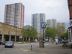 | ||
Ponders End is a mid-sized commercial and large residential district of the London Borough of Enfield, north London adjoining to its east the Lee Navigation in the mid-Lea Valley. It has a central high street, the Hertford Road and is formed from parts of the north of Edmonton and the south of Enfield.
Contents
- Map of Ponders End Enfield EN3 UK
- Geography
- Etymology
- History
- Popular culture
- Historic buildings
- Nearest places
- Watercourses
- Sport
- Nearest railway stations
- Demography
- Notable people
- Local newspapers
- Politics
- Schools
- Higher education
- Places of worship
- Open spaces
- References
Map of Ponders End, Enfield EN3, UK
Wright's Flour Mill here is the oldest working industrial building in the London Borough of Enfield.
Geography
Elevations range from 21 metres (69 ft) to 13 metres (43 ft) above sea level, uniformly dropping from west to east. Two north-south railway lines enclose the residential parts of the area, bounded east and west by estates of warehousing, industrial and commercial use, one of which, Meridian Water area has the much under-utilised Angel Road railway station and is the subject of major reconstruction including 5000 homes and 3000 new jobs and a wide range of community facilities. The railways are:
Its northern and southern limits are along Hertford Road at The Ride and The Boundary pubs (north to south). Its loosely defined east and west limits coalesce around Wharf Road in the east and the Southbury station or Kingsway in the west.
Etymology
Ponders End is marked on the Ordnance Survey map of 1822. It was recorded in 1593 as Ponders ende meaning the "end or quarter of the parish associated with the Ponder family" from the Middle English ende. John Ponder is mentioned in a document of 1373; the surname is believed to mean a "keeper of, or dweller by, a fish-pond or mill-pond".
History
All but a southern belt of the district was in Enfield, as the south lay in Edmonton, the parishes becoming a civil and ecclesiastical after a split of functions in the 1860s, which saw the final secularisation of government, the disestablishment of the vestries following the increase in Poor Law Unions in the hundred years before.
Through the 19th century the area became industrialised, due to its straight road and waterway network up and down the Lea Valley including the 17th century River Lee Navigation. The first major firm to arrive was Grout, Baylis & Co, who were established in Norwich in 1807 as crape manufacturers, the material being used for widows' weeds. They opened a dyeing and finishing plant in Ponders End two years later. Crape went out of fashion by late Victorian times, and the factory closed in 1894. The buildings were taken over by the United Flexible Tubing Company.
In 1866 the London Jute Works Company established a factory on the Navigation in a desolate area known locally as Spike Island. Many of the new employees came from Dundee, the traditional centre of the jute industry in Scotland. The jute works closed in 1882, to be replaced by the Ediswan factory. Over the years the factory was enlarged, eventually covering 11.50 acres (4.65 ha), and employing many people, notably girls, from the area. Ediswan produced electric lamps, and the factory was colloquially known as The Lamp. They also manufactured appliances for the shipping and aviation industries, mechanical pianos and butter makers.
To the south of Ponder's End Lock a factory making white lead was built in 1893. Further south of that factory, the Cortecine works produced floor-cloth and carpet backing. By 1906 over 2000 people were employed in local factories. Another major industry in the latter years of the 19th century was horticulture. Tomatoes and cucumbers were the principal produce but flowers and fruit were also grown in the many orchards and greenhouses to the north of the locality. During World War I, a huge munitions factory, the Ponders End Shell Works was built in Wharf Road. The factory building was sold after the war. Further factories were built in the 1930s alongside the newly built Great Cambridge Road.
Today (2009) little remains of manufacturing and much of the area has given way to warehousing and residential developments. Aesica pharmaceutical manufacturers (formerly Thomas Morson Ltd) closed its plant in 2011. Wright's Flour Mill, the oldest working industrial building in the borough remains, some of its buildings having been constructed in the 18th century.
On 7 August 2011 Ponders End was the scene of copy-cat riots which spread from Tottenham to neighbouring districts.
Popular culture
Musician Jah Wobble was inspired to write his (2005) album Mu by his experiences in the Lea Valley and Ponders End.
Ponders End Allotments Club is a track from the (1975) Chas and Dave album One Fing 'n' Annuver.
Historic buildings
Nearest places
Watercourses
Sport
Nearest railway stations
Demography
The 2011 census showed that 45% of the population was white (26% British, 17% Other, 2% Irish), 16% Black African and 8% Bangladeshi.
Notable people
Local newspapers
The local newspapers are as of 2011:
Politics
After boundary changes in 2010 - Ponders End became one of seven wards which form the Edmonton parliamentary constituency. The MP for constituency is Andy Love, Labour Co-op who polled 21,665 votes (53.7%) at the General Election held on 6 May 2010.