
Time zone EST (UTC−5) Area code(s) 450 and 579 Area 10 km² Province Québec | Constituted May 1, 1961 Postal code(s) J0P 1M0 Highways Route 338 Population 1,340 (2011) Local time Wednesday 2:22 PM | |
 | ||
Weather -9°C, Wind W at 27 km/h, 40% Humidity | ||
Pointe-des-Cascades is a village municipality in Vaudreuil-Soulanges Regional County Municipality in the Montérégie region of Quebec, Canada. It is located on a spit of land where the Saint Lawrence River flows into Lake Saint-Louis. The river has here a significant drop, forming several cascades which give the village its name.
Contents
Map of Pointe-des-Cascades, QC, Canada
History
Starting in the mid seventeenth century until 1700, many military expeditions arrived at this place in order to portage around the cascades on the Saint Lawrence River. The first reference to Pointe-des-Cascades appeared in a text of Louis-Armand de Lahontan in 1684 and on a map of Deshayes in 1695, when Pointe des Cascades was included in the Vaudreuil Lordship.
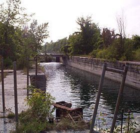
In 1893, the post office opened under the English name Cascades Point (renamed in 1951 to Pointe-des-Cascades). A few years later construction began on the Soulanges Canal and when it was completed in 1899, the village became the eastern, downstream terminus of the canal. In 1958, it closed when it was superseded by the new Beauharnois Canal. The paths along the canal are now being used as a regional cycling route.
In 1961, the Village Municipality of Pointe-des-Cascades was formed on the territory of the Parish Municipalities of Saint-Joseph-de-Soulanges and Saint-Michel-de-Vaudreuil.