
Country United States County Ocean Elevation 7 ft (2 m) Population 4,642 (2013) | Incorporated May 18, 1886 Zip code 08742 | |
 | ||
Area rank 427th of 566 in state19th of 33 in county Weather 5°C, Wind NW at 42 km/h, 24% Humidity Points of interest Jenkinson's Boardwalk, Jenkinson's Aquarium, Point pleasant beach, Lighthouse Point Miniature, Jenkinson's | ||
Point Pleasant Beach is a borough in Ocean County, New Jersey, United States. As of the 2010 United States Census, the borough's population was 4,665, reflecting a decline of 649 (-12.2%) from the 5,314 counted in the 2000 Census, which had in turn increased by 202 (+4.0%) from the 5,112 counted in the 1990 Census.
Contents
- Map of Point Pleasant Beach NJ 08742 USA
- History
- Geography
- Census 2010
- Census 2000
- Local government
- Federal state and county representation
- Politics
- Education
- Roads and highways
- Public transportation
- In popular culture
- Notable people
- Defunct
- References
Map of Point Pleasant Beach, NJ 08742, USA
Point Pleasant Beach was incorporated as a borough by an act of the New Jersey Legislature on May 18, 1886, from portions of Brick Township, subject to the results of a referendum passed the previous day.
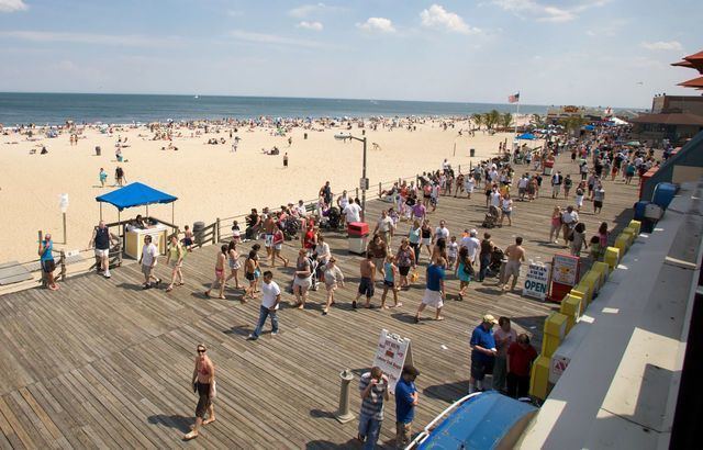
The borough is situated on the Barnegat Peninsula, a long, narrow barrier peninsula that divides the Barnegat Bay from the Atlantic Ocean at the Manasquan Inlet, and the borough derives its name from this location. The borough's boardwalk is approximately one mile long, spanning the coastline from the Manasquan Inlet at the north to New Jersey Avenue in the south. The central third of the boardwalk is largely amusement rides, the Jenkinsons Arcades, pizza joints, ice cream parlors, games-of-chance and miniature golf courses. Point Pleasant Beach is also the northern terminus of the East Coast's Intracoastal Waterway. It is near Point Pleasant borough, a municipality independent of Point Pleasant Beach.
It was ranked the eighth-best beach in New Jersey in the 2008 Top 10 Beaches Contest sponsored by the New Jersey Marine Sciences Consortium.
History
The area that includes Point Pleasant Beach was first used by the Lenape Native Americans. On September 2, 1609, Henry Hudson and the crew of his ship, Half Moon, noticed the area on their way north to explore the Hudson River. Crew member Robert Juet noted in his journal, "This is a very good Land to fall with and a pleasant Land to see." The first European settlers were fisherman and farmers who first arrived in the 18th century. Summer tourism began in the early 19th century when Quaker Thomas Cook Jr. opened his farmhouse on the site of the current Antrim Elementary School to boarders, which began the trend that transformed the area into an oceanfront haven for visitors, a trend further established in the 1870 by Captain John Arnold, who built a roadway to the ocean, now known as Arnold Avenue. In 1875, he built the first bridge over the Manasquan River, linking the town to Brielle. He later convinced the Central Jersey Railroad to extend its service to Point Pleasant Beach, which it did beginning on July 3, 1880.
The Borough of Point Pleasant Beach was established on June 2, 1886.
The 1870s was an era of major tourism expansion, driven by developers who subdivided old farms for vacation home lots. Captain Arnold devised Arnold City between Central and what was to become Arnold Avenue. In 1877, the Point Pleasant Land Company bought the old Forman Farm, 250 acres (1.0 km2) on what is now Route 35 South, between Forman and Elizabeth Avenues and began selling lots. In 1878, it built the four-story, 200-guest Resort House, the largest building in town. It also began a horse-drawn trolley service to attract tourists. Other hotels were built before the turn-of-the-20th century, including the largest, the Leighton, as well as the Beacon, and Zimmerman's, though many of these, including the Resort House, burnt down, succumbed to changing tastes, or were dismantled for wood during World War II. Initially, visitors focused their attention on the Manasquan River, cedar groves and farmhouses, but their interest in the ocean led to development on the waterfront, beginning with the first beachfront pavilion on Atlantic Avenue in 1880. Ten years later, the first flimsy, portable boardwalk was built, but it washed away within two years.
The original amusement area was Clark's Landing, which opened on the Manasquan River in 1892. In 1897, the decision for privately owned beaches in Point Pleasant Beach was made when, as noted in the Council minutes of August 16, "Ownership of the Beach turned down by the Council because of the extreme cost to the Borough for maintenance." In 1915, the first permanent boardwalk was built between Philadelphia and Central Avenues, and eventually expanded along the entire length of Point Pleasant Beach, but shortened to its present length by a September 1938 hurricane that destroyed its southern portion. It evolved from a mere promenade for strolling to a more active amusement area, beginning with Charles Jenkinson's construction in the 1920s of Jenkinson's Pavilion and Swimming Pool. The boardwalk pavilion became the center of nightlife, featuring sophisticated dancing, well-known big bands, and occasional live nationally broadcast radio. Today it features a number of amusement rides, video arcades, and diverse cuisine, ranging from the traditional sausage sandwich to sushi. Point Pleasant Beach hosts an annual Seafood Festival in September.
On February 12, 1900, the steel-hulled, Scottish barque, County of Edinburgh was blown ashore at high tide and became stranded. The event became national news when it was extensively reported in The New York Times, illustrated by a high quality photograph that became the resource for a famous painting by Antonio Jacobsen. The undamaged vessel was successfully re-floated on the spring tide of February 14 and continued on her voyage from Cape Town to New York.
In October 2012, Point Pleasant Beach and numerous other Jersey Shore communities, such as Seaside Heights and Long Beach Island, were devastated by Hurricane Sandy. Nearly 2,800 feet (850 m) of the borough's boardwalk was destroyed, with the cost of repairs estimated as up to $2 million.
Geography
According to the United States Census Bureau, the borough had a total area of 1.744 square miles (4.516 km2), including 1.427 square miles (3.695 km2) of land and 0.317 square miles (0.821 km2) of water (18.18%).
Unincorporated communities, localities and place names located partially or completely within the township include Clark's Landing, Lovelandtown and Sunshine Harbor.
The borough borders Bay Head and Point Pleasant in Ocean County and both Brielle and Manasquan in Monmouth County.
Census 2010
The 2010 United States Census counted 4,665 people, 1,985 households, and 1,122 families residing in the borough. The population density was 3,270.1 per square mile (1,262.6/km2). The borough contained 3,373 housing units at an average density of 2,364.4 per square mile (912.9/km2). The racial makeup of the borough was 92.35% (4,308) White, 0.84% (39) Black or African American, 0.15% (7) Native American, 0.84% (39) Asian, 0.02% (1) Pacific Islander, 4.52% (211) from other races, and 1.29% (60) from two or more races. Hispanics or Latinos of any race were 9.02% (421) of the population.
Out of a total of 1,985 households, 22.5% had children under the age of 18 living with them, 43.3% were married couples living together, 8.9% had a female householder with no husband present, and 43.5% were non-families. 36.0% of all households were made up of individuals, and 12.5% had someone living alone who was 65 years of age or older. The average household size was 2.30 and the average family size was 3.04.
In the borough, 18.9% of the population were under the age of 18, 7.2% from 18 to 24, 22.7% from 25 to 44, 33.6% from 45 to 64, and 17.5% who were 65 years of age or older. The median age was 45.7 years. For every 100 females the census counted 103.6 males, but for 100 females at least 18 years old, it was 103.6 males.
The Census Bureau's 2006-2010 American Community Survey showed that (in 2010 inflation-adjusted dollars) median household income was $57,792 (with a margin of error of +/- $6,541) and the median family income was $65,402 (+/- $16,995). Males had a median income of $54,327 (+/- $12,359) versus $39,076 (+/- $6,800) for females. The per capita income for the borough was $39,250 (+/- $5,121). About 5.8% of families and 8.4% of the population were below the poverty line, including 21.0% of those under age 18 and 3.4% of those age 65 or over.
Census 2000
As of the 2000 United States Census there were 5,314 people, 2,317 households, and 1,316 families residing in the borough. The population density was 3,696.0 people per square mile (1,424.8/km2). There were 3,558 housing units at an average density of 2,474.7 per square mile (954.0/km2). The racial makeup of the borough was 95.94% White, 0.53% African American, 0.34% Native American, 1.02% Asian, 0.02% Pacific Islander, 1.47% from other races, and 0.70% from two or more races. Hispanic or Latino of any race were 4.40% of the population.
There were 2,317 households out of which 22.9% had children under the age of 18 living with them, 43.3% were married couples living together, 9.6% had a female householder with no husband present, and 43.2% were non-families. 36.3% of all households were made up of individuals and 14.4% had someone living alone who was 65 years of age or older. The average household size was 2.25 and the average family size was 2.96.
In the borough the population was spread out with 19.2% under the age of 18, 6.5% from 18 to 24, 28.6% from 25 to 44, 26.6% from 45 to 64, and 19.0% who were 65 years of age or older. The median age was 43 years. For every 100 females there were 101.6 males. For every 100 females age 18 and over, there were 99.9 males.
The median income for a household in the borough was $51,105, and the median income for a family was $61,250. Males had a median income of $40,507 versus $37,500 for females. The per capita income for the borough was $27,853. About 5.0% of families and 6.1% of the population were below the poverty line, including 2.9% of those under age 18 and 6.8% of those age 65 or over.
Local government
Point Pleasant Beach is governed under the Borough form of New Jersey municipal government. The governing body consists of a Mayor and a Borough Council comprising six council members, with all positions elected at-large on a partisan basis as part of the November general election. A Mayor is elected directly by the voters to a four-year term of office. The Borough Council consists of six members elected to serve three-year terms on a staggered basis, with two seats coming up for election each year in a three-year cycle. The Borough form of government used by Point Pleasant Beach, the most common system used in the state, is a "weak mayor / strong council" government in which council members act as the legislative body with the mayor presiding at meetings and voting only in the event of a tie. The mayor can veto ordinances subject to an override by a two-thirds majority vote of the council. The mayor makes committee and liaison assignments for council members, and most appointments are made by the mayor with the advice and consent of the council.
As of 2016, the Mayor of Point Pleasant Beach is Republican Stephen D. Reid, whose term of office ends December 31, 2019. Members of the Borough Council are Council President Thomas Vogel (R, 2016), George "Andy" Cortes (R, 2018), William R. Mayer (R, 2017), Andy Migut (R, 2017), Robert A. Santanello (R, 2018) and Thomas Toohey (R, 2016).
Federal, state and county representation
Point Pleasant Beach is located in the 4th Congressional District and is part of New Jersey's 10th state legislative district.
New Jersey's Fourth Congressional District is represented by Christopher Smith (R). New Jersey is represented in the United States Senate by Cory Booker (D, Newark, term ends 2021) and Bob Menendez (D, Paramus, 2019).
For the 2016–2017 session (Senate, General Assembly), the 10th Legislative District of the New Jersey Legislature is represented in the State Senate by James W. Holzapfel (R, Toms River Township) and in the General Assembly by Gregory P. McGuckin (R, Toms River Township) and David W. Wolfe (R, Brick Township). The Governor of New Jersey is Chris Christie (R, Mendham Township). The Lieutenant Governor of New Jersey is Kim Guadagno (R, Monmouth Beach).
Ocean County is governed by a Board of Chosen Freeholders consisting of five members, elected on an at-large basis in partisan elections and serving staggered three-year terms of office, with either one or two seats coming up for election each year as part of the November general election. At an annual reorganization held in the beginning of January, the board chooses a Director and a Deputy Director from among its members. As of 2015, Ocean County's Freeholders (with party affiliation, term-end year, residence and department directorship listed in parentheses) are Freeholder Director John C. Bartlett, Jr. (R, term ends December 31, 2015, Pine Beach; Finance, Parks and Recreation), Freeholder Deputy Director Gerry P. Little (R, 2015, Surf City; Human Services), John P. Kelly (R, 2016, Eagleswood Township; Law and Public Safety), James F. Lacey (R, 2016, Brick Township; Transportation) and Joseph H. Vicari (R, 2017, Toms River; Senior Services and County Operations). Constitutional officers elected on a countywide basis are County Clerk Scott M. Colabella (R, 2015, Barnegat Light), Sheriff Michael Mastronardy (R, 2016; Toms River) and Surrogate Jeffrey Moran (R, 2018, Beachwood).
Politics
As of March 23, 2011, there were a total of 3,385 registered voters in Point Pleasant Beach, of which 623 (18.4%) were registered as Democrats, 1,295 (38.3%) were registered as Republicans and 1,465 (43.3%) were registered as Unaffiliated. There were 2 voters registered to other parties. Among the borough's 2010 Census population, 72.6% (vs. 63.2% in Ocean County) were registered to vote, including 89.5% of those ages 18 and over (vs. 82.6% countywide).
In the 2012 presidential election, Republican Mitt Romney received 60.1% of the vote (1,373 cast), ahead of Democrat Barack Obama with 39.0% (891 votes), and other candidates with 0.9% (20 votes), among the 2,299 ballots cast by the borough's 3,559 registered voters (15 ballots were spoiled), for a turnout of 64.6%. In the 2008 presidential election, Republican John McCain received 58.1% of the vote (1,486 cast), ahead of Democrat Barack Obama with 40.1% (1,026 votes) and other candidates with 1.3% (34 votes), among the 2,557 ballots cast by the borough's 3,533 registered voters, for a turnout of 72.4%. In the 2004 presidential election, Republican George W. Bush received 59.2% of the vote (1,561 ballots cast), outpolling Democrat John Kerry with 39.2% (1,035 votes) and other candidates with 0.9% (32 votes), among the 2,639 ballots cast by the borough's 3,647 registered voters, for a turnout percentage of 72.4.
In the 2013 gubernatorial election, Republican Chris Christie received 74.5% of the vote (1,332 cast), ahead of Democrat Barbara Buono with 23.6% (421 votes), and other candidates with 1.9% (34 votes), among the 1,843 ballots cast by the borough's 3,502 registered voters (56 ballots were spoiled), for a turnout of 52.6%. In the 2009 gubernatorial election, Republican Chris Christie received 65.1% of the vote (1,280 ballots cast), ahead of Democrat Jon Corzine with 27.8% (546 votes), Independent Chris Daggett with 5.3% (105 votes) and other candidates with 0.5% (10 votes), among the 1,966 ballots cast by the borough's 3,425 registered voters, yielding a 57.4% turnout.
Education
The Point Pleasant Beach School District serves students in pre-kindergarten through twelfth grade. As of the 2014-15 school year, the district and its two schools had an enrollment of 695 students and 77.0 classroom teachers (on an FTE basis), for a student–teacher ratio of 9.0:1. Schools in the district (with 2014-15 enrollment data from the National Center for Education Statistics) are G. Harold Antrim Elementary School for grades PreK-8 (454 students) and Point Pleasant Beach High School for grades 9-12 (371 students).
In addition to the students of Point Pleasant Beach, the district also serves the students of Bay Head and Lavallette for grades 9-12 and those from Mantoloking for K-12, as part of sending/receiving relationships. Some outside students attend the district's schools on a tuition basis.
Roads and highways
As of May 2010, the borough had a total of 29.66 miles (47.73 km) of roadways, of which 18.50 miles (29.77 km) were maintained by the municipality, 7.86 miles (12.65 km) by Ocean County and 3.30 miles (5.31 km) by the New Jersey Department of Transportation.
Public transportation
NJ Transit trains stop at the Point Pleasant Beach station on Arnold Avenue with service on the North Jersey Coast Line north to Penn Station Newark, Hoboken Terminal, and Penn Station New York in Midtown Manhattan.
NJ Transit provides bus service between the borough and Philadelphia on the 317 route along with local service on the 830 route.
Ocean Ride local service is provided on the OC3A Brick - Point Pleasant and the OC4 Lakewood - Brick Link routes.
In popular culture
Composer Edward Manukyan, who lived in Point Pleasant Beach briefly in 2002, wrote the song "Point Pleasant Beach" about the borough.
Notable people
People who were born in, residents of, or otherwise closely associated with Point Pleasant Beach include:
Defunct
A kiddie train along the beach used to exist up until the early 1990s. In addition, a second Jenkinsons existed on the northern end of Point Pleasant Beach until the 1990s.