
- left Newfoundland Creek - elevation 0 ft (0 m) | - elevation 1,624 ft (495 m) Basin area 231.5 km² | |
 | ||
- right Bonesteel Creek, Quacken Kill, Sweet Milk Creek Similar | ||
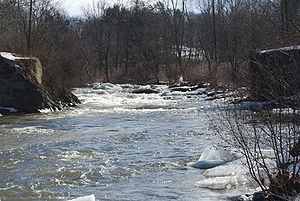
The Poesten Kill is a 26.2-mile-long (42.2 km) creek in upstate New York located entirely in Rensselaer County, which flows westerly from its source at Dyken Pond in the town of Berlin to its mouth at the Hudson River in the city of Troy. It has been used historically as a source of water for local inhabitants and farmers and became even more important as a source of water power during the Industrial Revolution, during which many mills and factories sprung up along its banks.
Contents
Map of Poesten Kill, New York, USA
Its name is derived from the name of a local farmer that lived near the creek in the 1660s, and the Dutch word kill, meaning creek.
GeographyEdit
The Poesten Kill begins at Dyken Pond, a man-made body of water located in the Petersburg Mountains, about 20 miles (32 km) east of the Hudson River. It was created by the Manning Paper Company in 1902 in an effort to control stream flow and prevent flooding. Dyken Pond is fed by local streams and springs and is located near the corners of the towns of Grafton, Berlin, and Poestenkill at an elevation of 1,624 feet (495 m).
While many small streams discharge into the Poesten Kill, there are only four notable tributaries of the creek. Bonesteel Creek runs southerly from Bonesteel and Hosjord Ponds and connects with the Poesten Kill in the town of Poestenkill between the hamlets of Barberville and Ives Corner. Bonesteel Creek is about 5.4 miles (8.7 km) long. Newfoundland Creek is the next tributary and joins the Poesten Kill just west of the hamlet of Poestenkill. It is about 3.6 miles (5.8 km) long. The Quacken Kill is the next tributary and connects in the town of Poestenkill near the Brunswick border. The Quacken Kill begins at Long Pond at Grafton Lakes State Park and continues through Second Pond and Mill Pond, also in the park, before continuing through Dunham Reservoir near central Grafton. It is about 15.9 miles (25.6 km) long. The next major tributary is Sweet Milk Creek, which begins as a stream in north central Brunswick and travels about 4.7 miles (7.6 km) before combining in the southwestern portion of the town.
The Poesten Kill travels about 26.2 miles (42.2 km) through Rensselaer County before flowing into the Hudson River.
Between 1924 and 1968, and at a location between Eagle Mills and Troy, the Poesten Kill saw an average of 130 cu ft/s (3.7 m3/s) in flow. It saw an average of 2,897 cu ft/s (82.0 m3/s) for peak flow in the same time period.
WaterfallsEdit
There are a number of notable waterfalls along the course of the Poesten Kill and its tributaries.
The DutchEdit
Prior to the arrival of Europeans, the Mohicans occupied the land through which the Poesten Kill flows. The first permanent European settlement in the area was Fort Orange, a trading post built by the Dutch West India Company in 1624, about 10 miles (16 km) south of the mouth of the creek. However, the mouth of the Poesten Kill at the Hudson is said to be first genuine European frontier settlement outside the barricades of Fort Orange.
The land making up much of current-day Albany and Rensselaer counties was sold by the Mohicans in 1630 to Kiliaen van Rensselaer, a Dutch merchant and businessman. With the land, Van Rensselaer began the only successful patroonship – essentially a feudal manor – in the history of the Dutch colonies: Rensselaerswyck. Van Rensselaer named the land surrounding the mouth of the Poesten Kill Pafraets Dael after his mother, Maria Pafraet. This can be seen on the first map of Rensselaerswyck, though the Poesten Kill is not identified.
The Dutch can be credited for the source of the creek's name. In 1661, Jan Barentse Wemp, an independent farmer-trader, began a lease for a farm with Jan Baptist van Rensselaer, Kiliaen's oldest son and the patroon at the time. The land extended south from the Poesten Kill to the north bank of the Wynants Kill, which empties into the Hudson in South Troy. At the time, residents would commonly go by a recognizable nickname, to distinguish themselves in local records. Wemp went by "Poest". Add the Dutch word kill, meaning "creek", and the source of the name Poesten Kill becomes clear.
While most of the settlements along or near the Poesten Kill during the Dutch era revolved around farming, some were also based on easy access to the Mohicans for trade in fur. The Indians, likewise, were more than happy to cut their trip by miles, since they would no longer have to go to Fort Orange. At the time, the fur trade was legally monopolized by the Dutch West India Company, so this practice was illegal, but very profitable.
Rensselaerswyck was taken over by the English in 1664, though the legal existence of the patroonship was not challenged.