
Population 2,118 (2013 census) | Local time Wednesday 2:59 PM | |
 | ||
Weather 18°C, Wind N at 23 km/h, 92% Humidity Train station Plimmerton Railway Station | ||
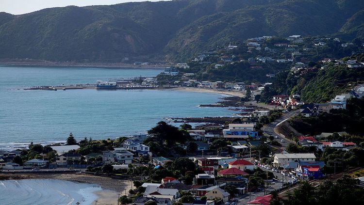
The suburb of Plimmerton lies in the northwest part of the city of Porirua in New Zealand, adjacent to some of the city's more congenial beaches. State Highway 1 and the North Island Main Trunk railway line pass just east of the main shopping and residential area.
Contents
- Map of Plimmerton Porirua 5026 New Zealand
- History
- Official name
- Demographics and census information
- Localities
- References
Map of Plimmerton, Porirua 5026, New Zealand
Plimmerton has its modern origins as a late 19th Century seaside resort. It is named after John Plimmer, an English settler and entrepreneur who, through the Wellington and Manawatu Railway Company, helped to fund and direct construction of the railway line. Today, around 2,100 people reside in the suburb.
History
The area was first settled by the Māori people early in their occupation of New Zealand. Ngāi Tara and then Ngāti Ira settled south of Kapiti, and a number of other tribes may have lived in the area including Muaūpoko, Ngāti Apa, Ngāti Kahungunu and Ngāti Hotu.
Ngāti Toa people took control of the Porirua coast in the 1820s. In the 1840s the area where Plimmerton is situated was the home of Te Rauparaha, who had his main residence at Taupo Pa. Te Rauparaha was captured by 200 British troops and police on 23 July 1846 near the southern end of Motuhara Road. A tiny historic reserve contains a cabbage tree that may be descended from the one he was said to have been captured near, and a plaque. Over the next few years Taupo Pa was deserted and the main Ngāti Toa villages in Porirua became Takapuwahia and Urukahika.
The area was leased for farming by European settlers over the following decades. These included William Cooper, Canington (possible Carrington), and then Levi Tandy (from 1859). James Walker farmed from Paremata to Plimmerton beginning in 1875.
The settlement was originally known as Taupo after the pa, and when the Horokiwi Valley Road was opened fewer travellers followed the Taua Tapu track through Taupo to Pukerua Bay. So Pauatahanui grew at the expense of Taupo until the railway line was opened in 1885. In the 1880s the Wellington and Manawatu Railway Company decided to build a railway link from the capital, Wellington, to Longburn, near Palmerston North. Several towns, including Plimmerton, were established along the way to encourage settlements that would contribute to the line's business. John Plimmer, after whom Plimmerton was named, was a director of the company.
In 1885 the first excursion train journeyed from Wellington to Plimmerton on 3 September, and regular services began from 10 October. With the railway's arrival, Plimmerton became accessible to holidaymakers, and evolved into a seaside resort. Plimmerton House, a two-storied hotel, was built alongside the railway station in 1886 (and burnt down in 1907). Sections began to be sold in 1888 and by the late 1890s Plimmerton had become a popular holiday destination. In 1900 Plimmerton consisted of 30 summer cottages, two private hotels and one general store.
Plimmerton was originally part of Hutt County. On 1 April 1973 the still-growing area became one of the northern suburbs of Porirua. Though small, it was one of the most lively. For a time it had the only active Residents' Association in the city.
Official name
The name Plimmerton was used in promoting the railway and advertising of sections for sale from the mid-1880s.
Plimmerton was gazetted as an official geographic name on 3 November 2011. The suburb amalgamated the previous recorded suburb names of Plimmerton and Karehana Bay. It excludes the largely Māori (Ngati Toa) settlement of Hongoeka to the west, which was gazetted on 16 December 2010.
Demographics and census information
The population of the Plimmerton area unit (which includes Hongoeka) at the 2013 census was 2,118, up slightly from 2,058 recorded in 2006 and 2,052 in both the 1996 and 2001 counts.
The 2013 census count comprised 1,056 males and 1,059 females in 840 dwellings. 14.2% were aged 65 or older (14.3% for New Zealand as a whole) and 19.7% were 15 or younger (NZ 20.4%). The largest ethnic groups were European (90.7%, compared to 74.0% in NZ) and Māori (12.5%, compared to 14.9% in NZ). 23.1% of residents were born overseas (NZ 25.2%), most commonly in the UK or Ireland. Plimmerton residents were relatively highly educated, with 35.6 percent of people aged 15 years and over having a bachelor's degree or higher, compared with 20.0 percent for New Zealand. Median annual income for those aged 15+ was $44,900 (NZ $28,500).
Localities
State Highway 1, here named St Andrews Road, passes through Plimmerton, as does the North Island Main Trunk railway line.
A shopping area about two blocks long adjoins Plimmerton Railway Station on Steyne Avenue and includes two churches, a medical centre, Plunket rooms, a craft shop, a beauty salon, real estate agents, a grocery store and several eateries. Plimmerton School, Plimmerton Kindergarten, and tennis courts are close.
To the north alongside the railway line is Plimmerton Domain, comprising 3 football fields, home to the Mana Archery Club, Wellington 29th Boys' Brigade and the Mana Arts Society. Beyond is the Plimmerton Industrial Estate, which includes numerous businesses, the Plimmerton Croquet Club, and a storage facility for the New Zealand Film Archive.
The Mainline Steam railway preservation group have their extensive restoration facilities located behind Plimmerton Railway Station.
North of the industrial area is the Taupo Swamp, a flax swamp, one of the largest of its type in the southern half of the North Island. Taupo Stream passes south through the swamp, along the east edge of Plimmerton Domain, between Steyne Avenue and St Andrews Road, and then flows into the sea at the north end of South Beach.
Plimmerton Library, which was part of Porirua City Council's library system, closed on 27 July 2012. It opened in the late 1940s and operated from a single-room building near the school from November 1951 until December 2007. It then shifted to the Plimmerton Pavilion, opposite the Plimmerton Volunteer Fire Brigade building, until its closure.
South-west of the shopping area is Plimmerton Beach, a fairly sheltered, gently graded beach, which has been a popular recreation area for over a century. It is popular with windsurfers; some world champions have trained there. At the southern end is South Beach. Recreational water quality at Plimmerton Beach is rated "fair" by the Greater Wellington Regional Council; water quality at South Beach is rated "poor", however, due to periodic faecal contamination. This contamination may originate from Taupo Swamp (via Taupo Stream), which often supports a large waterfowl population.
Another popular beach is Karehana Bay, at the foot of the Airlie Road/Cluny Road valley about 1.5 kilometres north-west of the shops. Poet Denis Glover mentioned the settlement in his poem Threnody: "In Plimmerton, in Plimmerton, the little penguins play, and one dead albatross was found at Karehana Bay"