
 | ||
Weather 31°C, Wind S at 14 km/h, 58% Humidity | ||
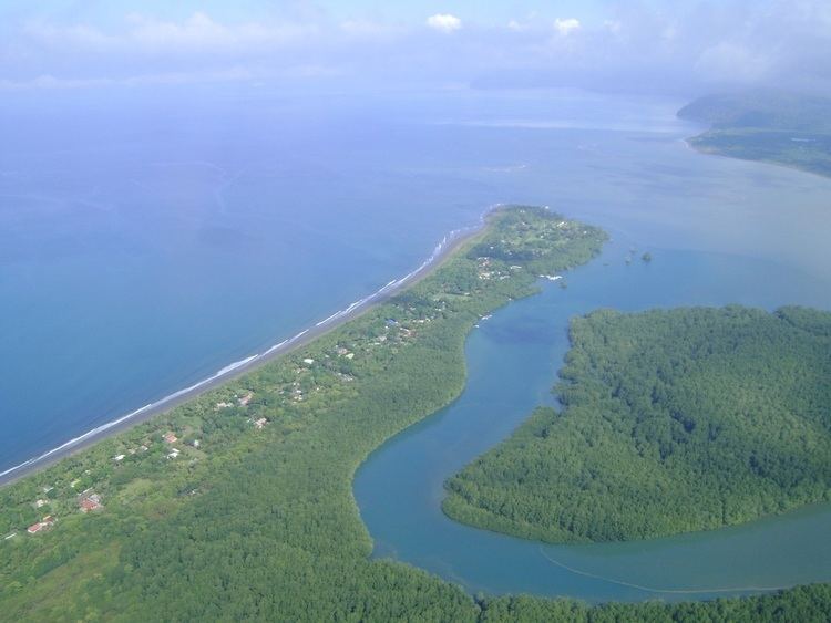
Playa Zancudo is a village in Puntarenas Province, Costa Rica near the Golfo Dulce. It has a population of approximately 450.
Contents
Map of Puntarenas Province, Zancudo, Costa Rica
Geography
It is located 9.5 kilometers south of Golfito. Zancudo is located on a long and narrow peninsula, sometime only 100 yards wide, at the mouth of the Rio Colorado. On one side of the peninsula is Zancudo's beach, protected from the full force of Pacific waves, while the other is home to a mangrove swamp. The whole beach is 6 miles long, with the southern three miles of it having jungle and farmland on the east side and most of the town being located within the northernmost mile. The town of Playa Zancudo contains a school, several churches, a soccer field, some Tico restaurants and bars, three sportfishing areas, and a general store.
History
The area around Golfito's port was developed by the United Fruit Company in the 1930s. While this was happening, excess bananas that washed down the Rio Coto river came upon Playa Zancudo's beaches. During this time, pig farms thrived on the leftover bananas. Gringos began moving to Zancudo in the 1980s, with the rise in foreign settlement aiding the demise of pig farming in Zancudo.
Transportation
The nearest airport is in Golfito.
The dirt road which connects the community is in severe disrepair, which prohibits bus service in and out of the town. This has been a major problem to its inhabitants, especially for the youth since they must travel to nearby communities daily for school. An odd consequence of this is that groups of up to 25 students have been forced to collectively rent pickup trucks for a daily charge.