
Highest point 194 m Municipality Krk (town) Area 8.64 km² | Population 0 (2010) | |
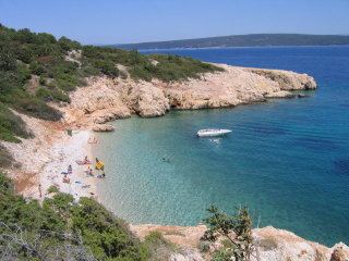 | ||
Plavnik is an unpopulated islet, belonging to Croatia located between the Central Straits and the Kvarner Bay. The Krusija Channel cuts it off from the eastern coast of the island of Cres. This channel is the shortest route from the Adriatic Sea through the islands to Rijeka. A lighthouse established in 1890, sits at the northwestern point of the islet, marking the east side of the narrowest opening of the Krusija Channel.
Contents
Map of Plavnik, 51557, Krk, Croatia
Geography
While covering an area of 8.64 km2, the islet has a length of 6.3 kilometres (3.9 miles) and a width of up to 2.3 km (1.4 miles). Its highest elevation is 194 metres (636 feet). Most of the islet does not have vegetation. On the northern and north-eastern sides, the coastline is partially steep. Two islets that make up Kornati, lie to the southeast of Plavnik. In the middle of the straits between these islands and Plavnik, the sea depth is about 9 metres (30 feet).
Flora and Fauna
Plavnik is home to birds such as the wheateaters, pheasant, and white-headed vulture. Hares are common as well. As of 2010, the islet is in the process of being declared a zoological and botanical reserve.