
County Kent Length 42 km Source Gaines Township Country United States of America | Basin size 57 sq mi (150 km) Basin area 147.6 km² Mouth Grand River | |
 | ||
Main source Gaines Township, Kent County, Michigan River mouth Grand River at Grand Rapids, Michigan
581 ft (177 m) Discharge Average rate:
34 cu ft/s (0.96 m/s) Bridges Business Route M-21–Plaster Creek Bridge, Division Avenue–Plaster Creek Bridge Similar Lansing River Trail, Kal‑Haven Trail, Kalamazoo River Valley Trail, Hemlock Park, Millennium Park | ||
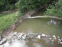
Plaster Creek is a 25.9-mile-long (41.7 km) urban stream in Kent County, Michigan in the United States. It is a tributary of the Grand River. The stream is named for the large deposit of gypsum found at its mouth. Its mean monthly flow averages 22 million gallons per day.
Contents
- Map of Plaster Creek Michigan USA
- WatershedEdit
- Flora and faunaEdit
- TributariesEdit
- TrailsEdit
- References
Map of Plaster Creek, Michigan, USA
Two bridges listed on the National Register of Historic Places cross the creek.
WatershedEdit
The headwaters are located in Dutton Park, at Hanna Lake Avenue and 76th Street, just south of the unincorporated town of Dutton in Gaines Township. The creek flows into the Grand River just south of Wealthy Street in downtown Grand Rapids. The main stream is approximately 26 miles (42 km) long and drains a 57-square-mile (150 km2) basin.
Flora and faunaEdit
Plaster Creek is a salmon spawning stream, and salmon have been seen as far upstream as Paris Park near Kalamazoo Avenue. The stream is not considered to be a trout stream, but has been designated as a warm water fishery. One endangered species Epioblasma triquetra (the snuffbox mussel) lives in the Plaster Creek watershed. The threatened Beak Grass (Diarrhena americana) grows along the banks in some areas.
TributariesEdit
Streams flowing into the creek include Little Plaster Creek, the small Maple Creek, and the former Silver Creek, now culverted as the Silver Creek Drain.
TrailsEdit
A series of trails along Plaster Creek is being planned in Grand Rapids:
Beginning at Ken-O-Sha Park School (1353 VanAuken SE) and following Plaster Creek, this pathway offers interpretive signs and a stunning display of spring-blooming wild flowers along the creek's bank and wetland areas. This portion of the Plaster Creek Trail is 1.2 miles (1.9 km).
The Plaster Creek extension is approximately 1.5 miles (2.4 km) in length. It starts at Plaster Creek and Eastern Avenue, travels north on the east side of Eastern Avenue, crosses 28th Street, then proceeds westerly to Division Avenue. The trail serves two purposes, as a non-motorized trail and as a flood protection and mitigation facility.
Division Avenue to Oxford Street.
Eventually, this trail will connect with Kent Trails and the Paul Henry Rail Trail.