
Isolation 16.9 km (10.5 mi) Elevation 3,279 m First ascent July 1859 | Prominence 1,164 m First ascender Johann Jakob Weilenmann | |
 | ||
Similar Pizzo Ferrè, Surettahorn, Pizzo Stella, Zapporthorn, Guggernüll | ||
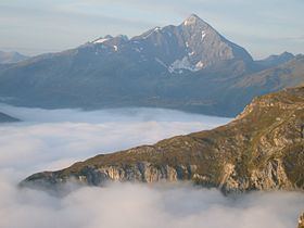
Pizzo Tambo [ˈpittso ˈtambo] or Tambohorn (Swiss names) or Pizzo Tambò [ˈpittso tamˈbɔ] (used in Italy) is a mountain located at the eastern extremity of the Lepontine Alps on the Swiss-Italian border. The mountain lies on the German-Italian language border, west of the Splügen Pass which divides the Western Alps from the Eastern Alps.
Map of Pizzo Tamb%C3%B2, Spl%C3%BCgen, Switzerland
Reaching a height of 3,279 metres, it is the highest peak in the Mesolcina sub-chain which, starting from the Lugano Prealps northwards, ends near the Splügen Pass on the boundary between Lombardy (northern Italy) and the Graubünden canton of Switzerland.
The Tambo is composed mostly of metamorphic rock such as gneiss, mica-schist and phyllite, with a small sector of dolostone just under the peak. It includes three small glaciers, the severally shrunk Tambogletscher on the northeast flank and the Ghiacciaio del Tambo on the west flank, both on the Swiss side, and the by now larger Vedretta della Spianata (3,000-2,740 m) on the southeast side in Italy. Southwards the massif continues with a series of smaller peaks (the highest being the Pizzo Zoccone) before joining the Pizzo Ferré.
Pizzo Tamborello (2,669 m) is the name of the eastern shoulder overlooking the Splügen Pass.