
Elevation 2,592 m (8,504 ft) Highest point Gran Cir | Range Dolomites Mountains Gran Cir | |
 | ||
Similar Dolomites, Gardena Pass, Plattkofel, Langkofel, Sass Rigais | ||
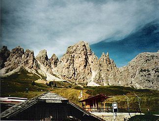
The Pizes de Cir (Ladin: Pizes de Cir; Italian: Gruppo del Cir [ˈɡruppo del ˈtʃir]; German: Cirspitzen) is a mountain range in South Tyrol, Italy. They are part of the Dolomites, north of Gardena Pass. The highest peak of this mountain range is the Gran Cir with an elevation of 2592 meters.
Contents
Gran Cir
The first tourist ascent to the peak took place on 7 August 1887 by Johann Santner and Gottfried Merzbacher from the west side. Today the Gran Cir is accessible via the normal route, a path not requiring climbing experience. The way leads first through a gravel field, then along a wall and high up to the summit. In some places, the way is secured with a wire. The top is marked with a large cross.
Piccola Cir
The peak of the Small Cir Italian: Piccola Cir has an elevation of 2520 meters. This peak is east of Gran Cir, close to the mountain station of the Dantercepies cable car. The top is marked with a small cross. It can be reached via a relatively easy via ferrata(B/C). The path leads, secured, from the eastern side to the summit, and then unsecured on the western side down again through a gravel field.