
Elevation 3,099 m Prominence 607 m | First ascent 1861 | |
 | ||
Easiest route To go up from the Pass dil Segnas along the ridge to the summit is the easiest route, only for experienced hikers though. Similar Piz Sardona, Piz Dolf, Fil de Cassons, Tschingelhörner, Ringelspitz | ||
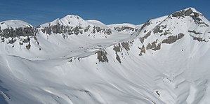
Piz Segnas is a mountain in the Glarus Alps, located on the border between the cantons of Glarus and Graubünden. Piz Sardona is lying on the same ridge to the north, from where the Trinserhorn or Piz Dolf lies to the southeast. The Tschingelhoerner with the famous Martinsloch (hole of St.Martin) is next to the west. The easiest access to the area is an aerial cableway to Fil de Cassons from Flims or the hike to this ridge lying southeast of Piz Segnas.
Map of Piz Segnas, 7017 Flims, Switzerland
References
Piz Segnas Wikipedia(Text) CC BY-SA