
Isolation 2 kilometres (1.2 mi) Prominence 250 m | Elevation 3,028 m | |
 | ||
Easiest route To Fuorcla Raschaglius and along Segnes Glacier to the north-westerly face and to the summit. Similar Piz Segnas, Piz Sardona, Fil de Cassons, Tschingelhörner, Ringelspitz | ||
Piz Dolf (Romansh) or Trinserhorn (German) is a mountain of the Glarus Alps, located on the border between the cantons of St. Gallen and Graubünden.
Map of Trinserhorn, 7017 Flims, Switzerland
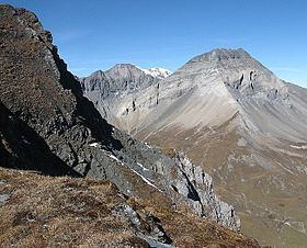
Piz Sardona is to the north across a glacier, and to its west Piz Segnas. Both Piz Segnas and Piz Dolf show the line of the Glarus thrust in its upper part. The easiest access to the area is an aerial cableway to Fil de Cassons from Flims or any of various hikes to this ridge lying southeast of Piz Dolf. One route uses the ascent via Val Bargis (the path can be seen on the picture (right) crossing the southern face of Piz Dolf in vegetation).
References
Piz Dolf Wikipedia(Text) CC BY-SA