
Prominence 942 m (3,091 ft) Elevation 3,210 m | Isolation 15.4 km (9.6 mi) First ascent 1865 Parent range Lepontine Alps | |
 | ||
Similar Cima di Camadra, Piz Terri, Piz Vial, Scopi, Rheinwaldhorn | ||
Piz medel 3210 m s l m
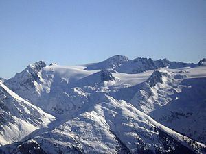
Piz Medel is a mountain in the Lepontine Alps, located on the border between the cantons of Ticino and Graubünden. At 3,210 metres (10,531 ft) above sea level it is the highest summit on the chain between Lukmanier Pass (1,915 metres) and Crap la Crusch (2,268 metres). The mountain overlooks the Greina, an important pass connecting the cantons of Graubünden and Ticino.
Contents
- Piz medel 3210 m s l m
- Map of Piz Medel 6720 Medels im Oberland Switzerland
- Skitouren piz medel medel lukmagn
- References
Map of Piz Medel, 6720 Medels im Oberland, Switzerland
The northern side of the massif (Graubünden) is covered by a large glacier named Glatscher da Medel, separated on its lower part in three branches. The massif consists of several summits among which the highest are Piz a Spescha (3,109 metres), Piz Cristallina (3,128 metres), Piz Uffiern (3,151 metres) and Cima di Camadra (3,172 metres).
The normal route to the summit starts at Fuorcla da Lavaz (2,524 metres), a pass connecting the northern valleys of Medel and Sumvitg. A hut has been erected on the pass by the Swiss Alpine Club, the Medel hut.