
First ascent 1895 | Elevation 2,880 m Prominence 501 m | |
 | ||
Similar Schlüechtli, Piz Tomül, Bruschghorn, Laaxer Stöckli, Alperschällihorn | ||
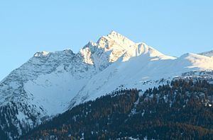
Piz Fess is a mountain of the Lepontine Alps, situated between the Val Lumnezia and Safiental in the canton of Graubünden. Piz Fess is the culminating point of the Signina range (Romansh: Cadeina dil Signina).
Map of Piz Fess, 7107 Riein, Switzerland
The mountain has two summits, a gentle summit named the Guter Fess ("Good Fess"; 2,874 m) and a not so gentle one named Böser Fess ("Angry Fess"; 2,880 m). In 1894 the pinnacle was still described as unclimbable, but the next summer Karl Viescher from Basel and the local guides Wieland Wieland and J. Christoffel reached the sharp summit.
References
Piz Fess Wikipedia(Text) CC BY-SA