
- right Milton Brook - elevation 219 m (719 ft) - elevation 43 m (141 ft) Country United Kingdom | ||
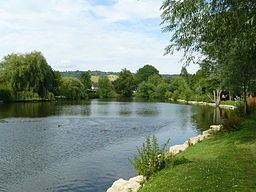 | ||
The Pipp Brook is a left-bank tributary of the River Mole, Surrey, England that descends steeply northward then flows east. It rises at two main springs in the Greensand Ridge, receives the Milton Brook which rises at a tri-forked source lower than its own, turns east descending less rapidly before discharging approximately half-way along the Mole's meandering northward course.
Contents
Map of Pipp Brook, United Kingdom
SourcesEdit
The geological varying depth of greensand top layers caused by erosion towards the underlying clay means that there is no uniform spring line in this part of the Greensand Ridge. The tower is the second highest point in the South-East of England. The Pipp Brook's main tributary, the Milton Brook rises at three close points in farmland on the indented north-east edge of the forest.
During the early nineteenth century the sulphate-rich (chalybeate) waters of the Mag's Well spring were attributed by a countryside travel writer as having aided a person's recovery.
Later CourseEdit
The north-south running watershed between the west branch of the close-together Pipp Brook and the Tillingbourne marks the boundary between Westcott, Surrey which the brook drains entirely and much larger Wotton. The Pipp Brook runs almost due east along its Dorking stretch north of much of the town and south of the steep scarp of the North Downs at Ranmore Common before joining the Mole at Pixham which was a hamlet of Dorking before achieving chapelry status and later full ecclesiastical parish status — part of which is the subject of occasional riparian (river) flooding as the rate of descent of the mole decreases significantly and at the Mole Gap becomes or became subterranean, depending on amount of sedimentation. The Pipp Brook itself has no sewage treatment works, few plains which it drains and as such an extremely narrow and low risk area of riparian flooding. These factors are instead present as to a few parcels of land of east Pixham sometimes considered Dorking by the national media based on a 2010s shorthand by the Environment Agency which has a 'Dorking Flood Area' comprising the sewage works, a handful of properties in Pixham and much of Brockham and Betchworth well upstream along the Mole to the east which are separated by more than a mile from Dorking and are narrowly in its post town.
WatermillsEdit
By the 19th century there were six corn/wheat grain mills on the river: Rookery Mill, Westcott Mill, Milton Court Mill, Parsonage Mill, Pipp Brook Mill and Pixham Mill none of which functioned since the mid-20th century when bread production was widely commercialised and the product was transformed to decrease its rate of degrading.