
County Norfolk ZIP Codes 02445 Area code 617 | Zip code 02445 | |
 | ||
Restaurants La Morra, Brick Wall Kitchen, Rita's Cafe, Pizza Stop, Dunkin' Donuts | ||
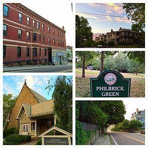
Pill Hill, also known as "High Street Hill," is a neighborhood of Brookline, Massachusetts, United States, and part of Greater Boston.
Contents
- Map of High Street Hill Brookline MA 02445 USA
- History
- Settlement and borders
- Climate
- Demographics
- Languages
- Culture
- Architecture
- Sites
- Light rail and subway
- Bus
- Public schools
- Notable residents
- References
Map of High Street Hill, Brookline, MA 02445, USA
History
Pill Hill became part of Brookline in 1844, when it was annexed from Boston.
Noted abolitionist, Samuel Philbrick, lived in Brookline at 182 Walnut Street during the mid-19th century. His home eventually became a stop for the Underground Railroad.
Like other Pill Hills in the United States, Pill Hill in Brookline was nicknamed for the large numbers of doctors in the neighborhood. That was likely due to its proximity to hospitals in the Longwood Medical and Academic Area of Boston. "High Street Hill" is the older and more formal name for the neighborhood. The neighborhood has been listed on the National Register of Historic Places as the Pill Hill Historic District. Pill Hill is one of seven Local Historic Districts in Brookline.
Settlement and borders
Pill Hill is centered along High Street, but also includes Allerton and Cumberland Streets, Hawthorn, Glen and Edgehill Roads and Pond Avenue.
Pill Hill immediately borders other Brookline neighborhoods, including Brookline Village to its north and the historically working-class neighborhood known as The Point ("Whiskey Point") to its south. Pill Hill also lies adjacent to Olmsted Park and Leverett Pond to its east (part of Greater Boston's Emerald Necklace park system); parkland which in turn borders the Boston neighborhoods of Jamaica Plain and Mission Hill.
The neighborhood is also near Route 9, a major Massachusetts highway.
Climate
Brookline falls under the USDA 6b Plant Hardiness zone.
Demographics
The most commonly reported ethnicities/ancestries in Pill Hill are Irish (20.7%), various Asian ancestries (14.6%), English (6.7%), Italian (6.5%), and Russian (6.1%). Additionally, 2.4% of those living in Pill Hill have Spanish ancestry.
17.9% of Pill Hill residents are foreign born.
Languages
The most common language spoken in Pill Hill is English, spoken by 72.9% of households. Other languages spoken in the neighborhood include Spanish, Chinese and French.
Culture
Pill Hill is mostly residential but also has places of commerce, particularly operating along Boylston Street/Route 9.
Architecture
The Pill Hill neighborhood of Brookline has various examples of Victorian architecture.
Sites
Light rail and subway
Pill Hill's close proximity to Brookline Village, allows for easy access to the MBTA's Green Line D-train at Brookline Village (MBTA station). Additionally, Pill Hill is within close proximity to the Green Line E-train line in the Mission Hill neighborhood of Boston, notably the Riverway stop.
Both D and E lines of the MBTA's Green Line have service to downtown Boston.
Bus
Pill Hill is also served by MBTA bus service.
Public schools
The local public school is the William H. Lincoln School.