
OS grid reference NY57666479 | Phone +44 370 333 1181 | |
 | ||
Address Similar Milecastle 48, Leahill Turret - Hadrian's, Milecastle 49, Milecastle 29, Milecastle 26 | ||
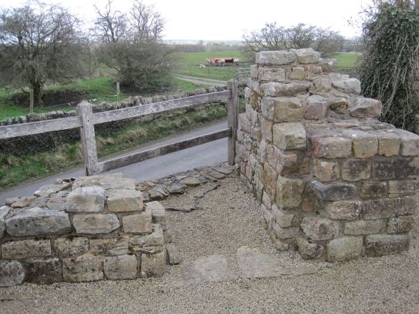
Pike Hill Signal Tower was one of a number of signal stations that were built along the Roman Stanegate in northern Britannia during the early 2nd century. It later became incorporated into Hadrian's Wall. Its remains, a 2-metre (6 ft 7 in) long fragment of the south-east wall, lie south of a modern road cutting and field wall, and are located in the parish of Waterhead in Cumbria, United Kingdom. The tower is located between Turret 51B and Turret 52A with the fort of Banna located to the east.
Contents
History
A signalling tower was built on Pike Hill during the Stanegate phase of fortifying the northern frontier of the Roman province of Britannia. Signalling towers and a number of forts were built along the line of the Roman road that connected significant military forts at Corbridge and Carlisle. This followed the withdrawal of the Roman army from Scotland around 100 and was prior to the construction of Hadrian's Wall which started in 125. The station at Pike Hill signalled to two nearby stations, Gillalees Beacon and Barrock Fell.
As Hadrian's Wall was extended through the area, the signal tower came to be incorporated alongside the newly constructed wall. The tower's location put it about 200 metres (660 ft) east of Turret 52A (Banks East) and west of Turret 51B (Leahill Turret).
It has been suggested that the signal tower was manned by part of Milecastle 52's garrison. The extra size of Milecastle 52 (20% larger than any other milecastle) has been cited as evidence for this.
Construction
Archaeological investigations have shown that the tower was built prior to either the turf or stone walls that exist nearby. The tower was offset from the wall and stood at an angle of 45° to the line of the wall. The purpose of this was to improve the visibility of the signal. A ditch lies to the north of the tower, following the same course as the tower resulting in a zig-zag line.
The signal tower was a square structure measuring around 6 metres (20 ft) on each side. The tower was built on a platform of mortared rubble and deep foundations have been found which indicate an upper structure of some extra height. The masonry was finished to a higher standard than the turrets found on the wall.