
Alternative name(s) Morbium, Vinovium Abandoned 5th or 6th century AD | Founded c. 2nd century AD Country England | |
 | ||
Address 2 B6275, Darlington DL2 3TA, UK Similar Piercebridge Roman Bridge, Stanwick Iron Age Fortifications, Vinovia, Bremenium, Walworth Castle | ||
Piercebridge roman fort
Piercebridge Roman Fort (possibly originally known as Morbium or Vinovium) is a scheduled ancient monument situated in the village of Piercebridge on the banks of the River Tees in County Durham, England. There were Romans here from about 70 AD until at least the early 5th century. There was an associated vicus and bath house at Piercebridge, and another vicus and a villa south of the river at Cliffe, Richmondshire. The Victorians used carved stones from this site when they built St Mary's church at Gainford, County Durham. Part of the site is under Piercebridge village green.
Contents
- Piercebridge roman fort
- 3d piercebridge roman fort
- Fort
- Structure of fort and bridge
- Vicus
- Bath house
- Archaeology
- Public display
- References
3d piercebridge roman fort
Fort
Lumps and bumps in the village green at Piercebridge indicate that underneath it is the Roman fort which was called Magis or Morbium. Dere Street was the main road through it, or Via Principalis. It was the furthest south of four forts along Dere Street in what is now County Durham, the others being at Binchester, Lanchester and Ebchester. Artefacts found in Piercebridge suggest that there were Romans on the site around the river as long ago as 70 AD, perhaps because there was a ford or ferry to be defended from the Brigantes. A civil settlement in the Toft field existed by 125 AD, and a military installation alongside Dere Street south of the Tees appeared in the late 2nd century. However the fortifications which can be seen today on the north side of the river were not built until 260 to 270 AD, when the other Roman settlements and vicus north and south of the river began to decrease in size. The fort was maintained from around 290 to 350 AD, with later development, by which time the inhabitants were mostly inside the fort area. It was inhabited until the 6th century, although some theories state that it was finally abandoned in the early 5th century. It is now a scheduled ancient monument. It was not the only Roman fort next to a bridge hereabouts; there was also Greta Bridge.
Structure of fort and bridge
The fort appears to have followed the standard Roman plan, being rectangular in shape with towers at each corner and two big gates for Dere Street. Inside would be barracks, workshops, granaries and the garrison headquarters with the commandant's separate accommodation. According to the 2005 Conservation Area appraisal, the bridge had a south abutment and four piers; however it has been suggested by some archaeologists such as Raymond Selkirk that the existing remains do not represent a bridge, and that it is a dam and spillway. If it is a Roman bridge, then it would be one of only two remaining in the country; the other one being Chesters Bridge. Whether or not a Roman bridge existed, there would have been a ferry here in the past, before any bridge was built.
Vicus
To the east of the fort in Tofts Field there is a vicus which began in the 1st century AD and survived into the early 5th century: a civilian settlement outside the fort's boundaries for providers of goods and services to the fort itself. Accordiing to cropmarks, it apparently consisted of about thirty buildings whose inhabitants probably traded via the river from the late 1st century, but fewer people lived there once the fort's defences were built. This vicus probably followed the building of the Roman villa south of the river at Holme House, which in turn began as a native roundhouse. There was an associated vicus at the other side of the river crossing, at Cliffe, Richmondshire.
Bath house
A Roman bath house was still standing at the south-east corner of the fort-site in the 13th century when St Mary's chapel was built to incorporate part of it: possibly the wall with rounded arched doorway which is still visible from a distance, on private land. In the traditional manner, the garrison bath house stands outside the fort itself. It is a Grade II* listed building and scheduled ancient monument.
Archaeology
Because modern Piercebridge never extended beyond the original Roman boundaries of the fort, the north and west earthworks are preserved, and part of this has been excavated. An excavation was made in 1938, where a guard chamber each side of the western gateway was found. They also exposed the wall of the outer rampart, near the north-west corner, and in 1939 exposed part of the south outer wall. Another dig was carried out by Dennis Harding and Peter Scott between 1969 and 1981. A 1973 dig found a 3rd-century rectangular building with hypocaust. A bronze figure of a ploughman with oxen, which is now in the British Museum, was found here along with Roman coins dated early 4th century. St Mary's 1855 church building at Gainford contains Roman worked stones from this site. Other finds have included kilns and Roman pottery, a metalworking site, a carved stone altar and burials including gravestones and a lead coffin. The archaeological television programme Time Team investigated Piercebridge Roman Fort in 2009, and at that time divers examined holes in the river bed which may have been Roman. Among the finds were a small lead goat and a hairpin. Inscriptions found here attest to the presence of members of the Legio II Augusta, the Legio VI Victrix, and the Legio XXII Primigenia, as well as worship of Jupiter and Mars. Around 1910, Edmund Wooler discovered a large, worked Roman stone which he believed to have been part of the original Roman bridge. The site has been reassessed by archaeologist Dr David Mason in 2006, and the archive from the excavations is at the Bowes Museum.
Public display
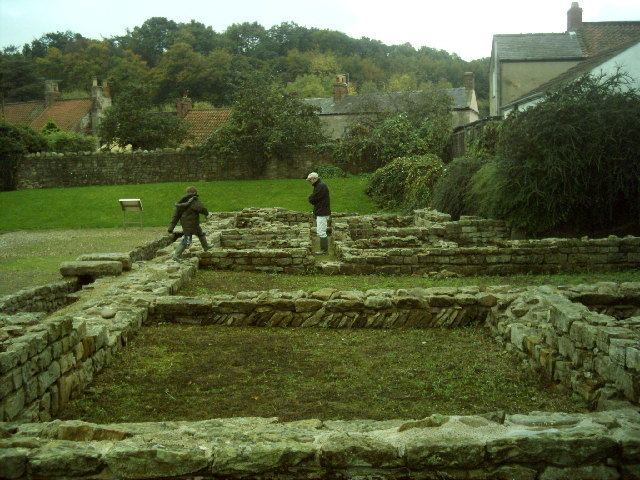
It is the eastern wall which can be seen today, with the remains of where the eastern gate was robbed out. The original rectangular defence pits are lawned over between the wall and the outer ditch. There were obstacle pits, and also man-traps or camouflaged holes spiked with large, pointed, wooden stakes for unsuspecting attackers to fall into. These were squareish holes, probably originally covered with undergrowth. Beyond the fort wall was a road with a drain or culvert which still exists. The commandant's substantial house is beyond this road and built on river-pebbles. He had his own bath-house, and this is the one at the north of the site on private property, but visible over a fence. Admission is free and the site is open to the public all year round. A large proportion of the substantial 11-acre (45,000 m2) fort now lies under later buildings; the village has never expanded beyond the old Roman boundary. Visible Roman remains at the eastern part of the site include parts of the east gate and defences, a courtyard building and an internal road, and a section of the eastern elevation is now preserved and on permanent public display. However it is believed that Roman residences were to the west of the revealed archaeology. Some of the artefacts found at the site are on show at Bowes Museum at Barnard Castle. Remains of the bridge – which may have carried Dere Street over the River Tees or may have been a dam and spillway – can be seen on the south side of the river at Cliffe, Richmondshire.