
OS grid reference NZ213156 | Phone +44 370 333 1181 | |
 | ||
Similar Ponte de Rubiães, Leontes Bridge, Nysa Bridge, Ponte di Quintodecimo, Piercebridge Roman Fort | ||
Piercebridge roman bridge
Piercebridge Roman Bridge is the ruin of a Roman bridge over the River Tees near the village of Piercebridge, County Durham, England.
Contents
The bridge carried Dere Street Roman road across the river. Piercebridge Roman Fort guarded the bridge.
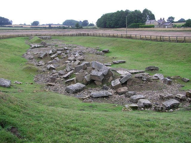
The Tees has narrowed and changed its course over the centuries so the remains lie in a field around 90 metres (300 ft) south of the current course of the river, and about 450 metres (1,480 ft) east of Piercebridge.
What remains of the bridge are massive masonry blocks that formed its piers. The lower courses of one of the abutments still stand, partially complete, and it is possible to see the holes into which the wooden structure of the bridge would have fitted. All of the timber has disappeared in the nearly 16 centuries since the end of the Roman occupation.
Alternative interpretation
Whilst the majority opinion among archaeologists is that the structure is a bridge, an alternative interpretation has been proposed by amateur archaeologist Raymond Selkirk, who contends that the structure is a navigation dam with an overspill channel. From this, and other evidence he argues that the Romans made far greater use of river transport than is generally recognised. His views are set out in his books The Piercebridge Formula (1983), On the Trail of the Legions (1995) and Chester-le-Street & Its Place in History (2000).