
Elevation 2,791 m Mountain range Mantiqueira Mountains | First ascent 1919 Parent range Mantiqueira Mountains | |
 | ||
Location States of Rio de Janeiro and Minas Gerais, Brazil Easiest route By car from Rio de Janeiro or São Paulo on the Dutra highway up to Engenheiro Passos; from there on BR-354 highway toward Itamonte until the Garganta do Registro mountain pass; then on a gravel road (BR-485) to Itatiaia National Park's north entrance and from there to Abrigo Rebouças mountain shelter; easy trek to the peak base; steep climb on rock afterwards. Similar Mantiqueira Mountains, Pedra da Mina, Pico da Bandeira, Pico dos Marins, Pico dos Três Estados | ||
Pico das Agulhas Negras ([ˈpiˌkuˌdaˌzaˈɡuˌʎɐsˈneˌgɾɐs]) is the fifth highest mountain in Brazil, standing at 2,791 metres (9,157 ft) above sea level, making it one of the highest in the Brazilian Highlands. It is located in Itatiaia National Park, in the Serra da Mantiqueira range, on the border of the states of Rio de Janeiro and Minas Gerais. It is the highest point in the state of Rio de Janeiro, the third highest peak in Minas Gerais, and the second highest in the Mantiqueira range.
Contents
- Map of Pico das Agulhas Negras Itatiaia State of Rio de Janeiro Brazil
- Etymology
- Geography
- Elevation measurements
- References
Map of Pico das Agulhas Negras, Itatiaia - State of Rio de Janeiro, Brazil
The climb to the top was first attempted by Franklin Massena in 1856. Further attempts were made by André Rebouças in 1878 and by Horácio de Carvalho in 1898, but the summit was only reached in 1919, by Carlos Spierling and Osvaldo Leal.
Etymology
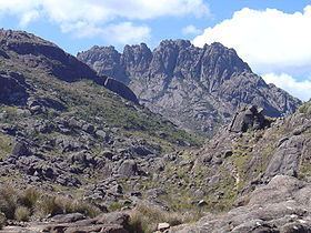
Its name means Black Needles Peak, because of the sharp dark rocks on its top, which give it a distinctive shape. The peak's massif is known as Itatiaia, which means "stone with many sharp points" in Tupi. The highest rock, with the summit, is known as Itatiaiaçu, or simply Açu (a Tupi suffix meaning "big") among Brazilian mountaineers.
Geography
Pico das Agulhas Negras can be seen to the northwest of Resende when driving between São Paulo and Rio de Janeiro on the Via Dutra highway, but this is only possible at a few points on the road, because a lower mountain range closer to the road stands in the line-of-sight at most other nearby spots.
A mountain shelter called Abrigo Rebouças is located near the base of the peak, at an elevation of about 2,350 m (7,710 ft). It is accessible by a badly maintained gravel road (BR-485) from the BR-354 federal highway at the Garganta do Registro mountain pass, via Itatiaia National Park's north entrance. The access road reaches an altitude of 2,460 metres (8,071 ft) at the entrance of the park, and a short spur from it leading to a communications tower of the Eletrobras Furnas electricity company reaches 2,662 metres (8,734 ft); these are the highest points one can reach in a regular car (as opposed to off-road vehicles) in Brazil.
Elevation measurements
For years, Pico das Agulhas Negras was thought to be the highest mountain in Brazil. The title later went to Pico da Bandeira, in the Caparaó range between the states of Minas Gerais and Espírito Santo (now known to be at 2,891 m or 9,486 ft). In 1965, it was found that Pico da Neblina, in the state of Amazonas, was in fact the highest, with a currently revised height of 2,995 metres (9,827 ft).
Even then, Pico das Agulhas Negras was still thought to be the highest point in the Mantiqueira Mountains, until a 2001 GPS measurement (later confirmed by an official joint expedition of the Brazilian Army and the Brazilian Institute for Geography and Statistics - IBGE) showed that nearby Pedra da Mina was that mountain range's highest point at 2,798 metres (9,180 ft), about seven metres higher than Agulhas Negras. Pedra da Mina was higher even though Agulhas Negras was also found to be slightly higher than previously thought, at 2,791.55 metres (9,158.6 ft), rather than its previous official altitude of 2,787 metres (9,144 ft). Pico das Agulhas Negras remains the highest point in Rio de Janeiro state.
In 2015, IBGE completed a new and more accurate mapping of the Brazilian territory regarding the geoid, the irregular imaginary surface based on the Earth's gravitational field that is the reference for altitude measurements. This led the institution to recalculate the altitude of the mountains measured in the earlier project, according to the new reference. The new data were published in February 2016. Pico das Agulhas Negras was then found to stand at 2,790.94 metres (9,156.6 ft), a difference of 61 cm or about two feet.