
Isolation 83 kilometres (52 mi) Elevation 3,011 m Prominence 3,011 m | Last eruption 1923 | |
 | ||
Listing Country high pointUltra Similar Mount Cameroon, Pico de São Tomé, Kinyeti, Rumpi Hills, Maromokotro | ||
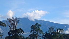
Pico Basilé (formerly Pico de Santa Isabel), located on the island of Bioko, is the tallest mountain of Equatorial Guinea. With an altitude of 9,878 ft (3,011 m), it is the summit of the largest and highest of three overlapping basaltic shield volcanoes which form the island. From the summit, Mt. Cameroon can be seen to the northeast. Pico Basilé lies close to the city of Malabo.
Contents
Map of Pico Basil%C3%A9, Equatorial Guinea
Bioko was formed along the Cameroon line, a major northeast-trending geologic fault that runs from the Atlantic Ocean into Cameroon. This line includes other volcanic islands in the Gulf of Guinea such as Annobón, Príncipe and São Tomé, along with the massive stratovolcano of Mount Cameroon.
Flora and Fauna
Part of the Cameroon line, the flora and fauna of Pico Basilé and Bioko as a whole are similar to that of the montane regions of adjacent Cameroon and Nigeria. Multiple range restricted species occur on Pico Basilé, and one bird, the Bioko Speirops Zoterops brunneus, is wholly restricted to the volcano's higher elevations.