
Isolation 3.6 km (2.2 mi) Prominence 201 m | Elevation 2,989 m Parent range Chablais Alps | |
 | ||
Similar Mont Ruan, Tour Sallière, Grenier de Commune, Le Cheval Blanc, Mont Buet | ||
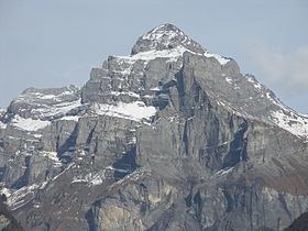
Pic de Tenneverge is a mountain of the Chablais Alps, located between the French department of Haute-Savoie and the Swiss canton of Valais. Its summit is 2,985 metre-high and lies within France, 300 metres west of the border with Switzerland (2,951 m). The mountain is located between Sixt-Fer-à-Cheval (France) and Lac d'Emosson (Switzerland).
Map of Pic de Tenneverge, 74740 Sixt-Fer-%C3%A0-Cheval, France
References
Pic de Tenneverge Wikipedia(Text) CC BY-SA