
Population (2014) 773 Area 119.1 km² | Canton Samoëns Time zone CET (UTC+1) | |
 | ||
Sixt-Fer-à-Cheval is a municipality in the Haute-Savoie department within the Auvergne-Rhône-Alpes region in southeastern France. It is located at the end of the Giffre Valley and set in an area of outstanding natural beauty.
Contents
Map of 74740 Sixt-Fer-%C3%A0-Cheval, France
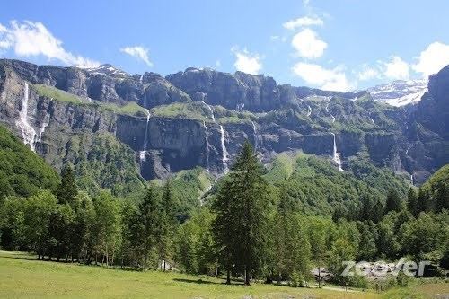
Sixt-Fer-à-Cheval is one of Les Plus Beaux Villages de France. Although the Cirque du Fer à Cheval has made Sixt famous, other attractions including the Cascade du Rouget waterfall, named "Queen of the Alps" and a nature reserve cover most of the district's geographical area. Its architectural heritage is exemplified by the priory and church stemming from the former Sixt Abbey, founded by Ponce de Faucigny.
Geography
The area of the town ranges in altitude from 728 to 3,098 metres (2,388 to 10,164 ft); three-quarters of its area (9,200 hectares out of 11,200 total) are part of a natural reserve and completely uninhabited.
The name Sixt-Fer-à-Cheval comes from the shape of the natural amphitheatre ("Cirque du Fer à Cheval") which, from above, looks like a horseshoe. Located in the Natural Reserve of Sixt, the Cirque du Fer à Cheval, classified a Grand Site de France is a favored destination for 500,000 visitors each year.
The heart of the village is the parish of the Abbaye. Sixt is divided into 12 parishes, along the two main rivers called Giffre des Fonts also called "Giffre-Haut" (Upper Giffre), and Giffre du Fer à Cheval. The Giffre river, a tributary of the Arve, has its source in Sixt-Fer-à-Cheval, coming from a few hundred waterfalls in the nearby mountains.
Four of the twelve parishes are located between the parish of the Abbaye and the Cirque du Fer à Cheval (Les Curtets, L'Echarny, Le Molliet, Nambride). The seven other parishes are located between the parish of the Abbaye and the Rouget Waterfall, in the upper Giffre valley (Maison Neuve, Salvagny, Passy, Le Fay, Hauterive, La Chapelle, and Englène). Sixt-Fer-à-Cheval is linked to the Samoëns' valley through one sole road.
The highest mountain in the village, the Mont Buet (also called "Women's Mont Blanc") reaches 3,099 metres (10,167 ft). Sixt shares important borders with Switzerland (on the northeast) and also Chamonix-Mont-Blanc (to the south). The village and its 11,200 hectares (28,000 acres) is recognized as one of Les Plus Beaux Villages de France (The Most Beautiful Villages of France), of which there are only five in all of the French Alps.
Mountain sports
Sixt is a year-round haven for mountain lovers, adventurers, walkers, skiers and mountain bikers: plentiful trails and paths among glorious alpine meadows, forests and abundant waterfalls, including the amazing Cascade du Rouget, "Queen of the Alps” waterfall, an easy 40-minute walk away from the village.
Sixt-Fer-à-Cheval is an authentic winter sports resort. Part of the famous Grand-Massif ski resort, Sixt is an ideal place for skiers and lovers of all forms of alpine activities (paragliding, via ferrata, mountaineering, ice-climbing, and rafting).
A cherished ski area which enables families of all abilities to enjoy the 265 km of slopes of the Grand Massif resort (Sixt-Samoëns-Flaine-Les Carroz) – from well-equipped beginner slopes to blue, red, black and incredible off-piste. Sixt owns the longest ski slope of the Alps, which you can access from the Grande Platières summit above Flaine. This celebrated 14 km "Piste des Cascades" all the way down to Sixt, 1,700 metres (5,600 ft) below, is an extraordinarily picturesque, gentle blue run through meadows, iced waterfalls and forests, where it is usual to see chamois and alpine ibex roaming freely.