
First ascent 1792 par des bergers ? | Elevation 3,219 m | |
 | ||
Parent range Massif du VignemalePyrenees Similar Cerbillona, Clot de la Hount, Grand Tapou, Pointe Chausenque, Piton Carre | ||
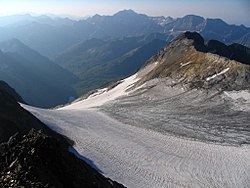
The Pic de Montferrat, culminating at 3,129 m (10,266 ft), is a crest summit on the Franco-Spanish border, in the massif du Vignemale in the Pyrenees.
Contents
Map of Pic de Montferrat, 65170 Aragnouet, France
Topography
It is located in the Hautes-Pyrénées department, between Cauterets eand Gavarnie, arrondissement of Argelès-Gazost in the Pyrenees National Park. It is bordered to the north by the glacier d'Ossoue and by le petit glacier du Montferrat to the south-east.
History
The first ascension was carried out by shepherds, on August 1, 1792, who built a turret on the summit, ordered by Louis-Philippe Reinhart Junker who led a team of geodesists in charge of defining the Franco-Spanish border path.
References
Pic de Montferrat Wikipedia(Text) CC BY-SA