
Elevation 3,289 m | Easiest route From Glacier d'Ossoue | |
 | ||
Similar Cerbillona, Vignemale, Piton Carre, Pointe Chausenque, Grand Tapou | ||
Couloir du clot de la hount massif du vignemale
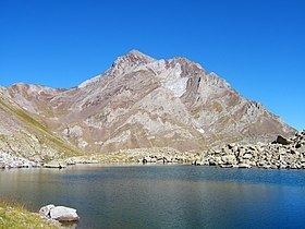
The Clot de la Hount or pic du clot de la Hount is a summit of the Pyrénées, located on the Franco-Spanish border in the Vignemale Massif, of which it is the second highest summit in the range, at 3,289 m, after Pique Longue (3,298 m).
Contents
- Couloir du clot de la hount massif du vignemale
- Map of Clot de la Hount 65170 Aragnouet France
- Toponymy
- Topography
- References
Map of Clot de la Hount, 65170 Aragnouet, France
Toponymy
The Clot de la Hount is a term coined by shepherds for the area near the bottom of the peak.
Hount refers to a spring source which flows intermittently (Hount meaning eye, or a passage that is sometimes open, sometimes shut).
Clot means either a ledge or a pen.
Topography
The French side is located in the Hautes-Pyrénées department, between Cauterets and Gavarnie, in the arrondissement of Argelès-Gazost which lies in the Pyrenees National Park. The southern Spanish side is in the Natural Reserve of Ordesa-Viñamala, in Torla territory, Huesca province.