
Province Bình Thuận | ||
 | ||
Incorporated 1933, as the Commune of Phan Thiết Consolidated 1999, as the City of Phan Thiết Named for Hamu Lithit(Cham language) | ||
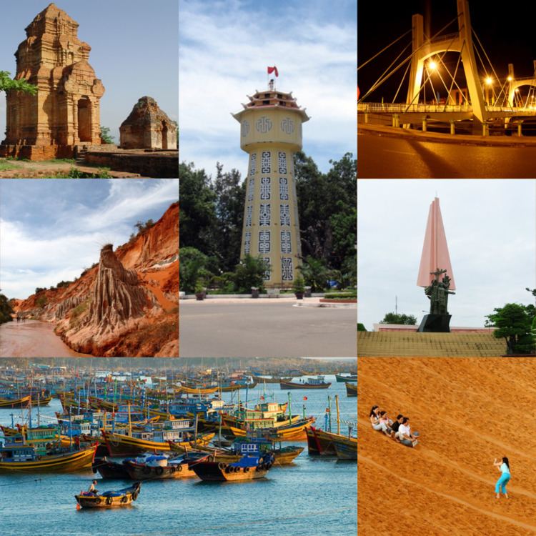
Phan Thiết ([fan.tʰíət]) is the capital of Bình Thuận province, on the coast in south-eastern Vietnam, where all government offices for the province are located. While most of the inhabitants live in the city center, the others live in the four wards, extending from Suoi Nuoc beach in the north-east to the Ke Ga lighthouse in the south-west.
Contents
Map of Phan Thiet, Binh Thuan, Vietnam
Traditionally, fishing and manufacturing of fish sauce has been the main source of Phan Thiet’s income thus far, the picturesque fishing fleet in the harbor colorful proof. Drawn by the beautiful beaches of the area, tourism is rapidly replacing the fish industry as the main employer.
The first resorts along the beaches of Hung Long and Phu Thuy wards, as well as Phu Hai and Ham Tien wards east of the city center appeared in the mid-nineties. Since then, tourism has boomed and hundreds of hotels, restaurants, resorts, guesthouses and shops have been constructed along the coastline.
Rang Beach in Ham Tien ward was discovered by foreigners in 1995, while they watched the solar eclipse. Misled by guidebooks, which incorrectly labelled Rang Beach as “Mui Ne Beach”, they were the first of a long row of tourists mistakenly calling everything east of the city center Mui Ne.
Each area of Phan Thiet has its own characteristics. The beaches of Ke Ga and Tien Thanh are peaceful and quiet, inviting tourists to swim and relax. There is not much traffic on the roads along the coastline, so walking or riding along the beach is quite peaceful.
Compared to Nha Trang, the density of resorts along the beaches of the city center in Phan Thiet is quite low, so when tourists leave their hotels, they step into the middle of the bustling daily life of a Vietnamese city. You can walk to many restaurants, museums or shopping malls - even visit the school where Ho Chi Minh taught before he went to study in Paris.
Phu Hai ward covers a hilly area along the coastline and has many small beaches and hidden coves. Many of the resorts in this ward are built above the water on the hills and have a small beach to themselves. Sea Links City, composed of a hotel, condos, apartments, a winery and a golf course is located here. Phu Hai is the place of the old Thap Poshanu Cham Tower, built in the 8th century and worth a visit.
Alongside the 10 kilometer strip of Rang Beach in Ham Tien ward, you will find a lively tourist strip. Hundreds of resorts, hotels, bars, restaurants, shops, and spas are situated here.
The downside is the advanced erosion of the beach, some resorts meanwhile lack a beach at high tide, when the water directly reaches the sea wall.
One of the great tourist attractions of Ham Tien is the so-called Fairy Stream, where a small stream has carved a canyon through the dunes, revealing colorful layers of sand.
Beyond Ham Tien you find Mui Ne, consisting of two communities, adding up to around 25,000 residents in the actual town and two beaches. The second community is Hon Rom, a real fishing village with a few hundred residents. Mui Ne has the highest population outside the city center and is quite lively in the morning. In the evening locals join together for coffee or dinner at the many cafés and restaurants.
Mui Ne actually translates to “Shelter Cape,” because for ages the local fishermen used the cape to shelter their boats from the wind. The town itself covers the west side of the cape, whereas many resorts are alongside Ganh Beach and Suoi Nuoc. A resort in Mui Ne ward is the right decision for people who want to be close to a local community, but keep their distance to the bustling tourist strip and rather prefer a quiet beach.
Another tourist attraction are the orange sand dunes, located on a hill between Mui Ne and Hon Rom. The larger white dunes are around 23 kilometers north of the town.
Phan Thiet operators usually make a distinction between winter and summer seasons. During winter, mostly Northern Europeans and Russians spend their holidays here, far away from the northern chill, to enjoy kitesurfing and windsurfing. In summer season, Phan Thiet is a popular destination for Australians and North Americans, as well as many Vietnamese escaping the steaming hot cities for a fresh breeze of sea wind.
Name
There are several theories about the origin of the name Phan Thiết most of which agree that, "Phan Thiết" is not a pure Vietnamese name:
History
Administrative divisions
Phan Thiết is subdivided into 18 wards and communes, of which 14 are urban wards, namely: Đức Thắng, Đức Nghĩa, Đức Long, Phú Hài, Phú Thủy, Phú Trinh, Phú Tài, Thanh Hải, Hàm Tiến, Mũi Né, Xuân An, Bình Hưng, Hưng Long, Lạc Đạo and 4 suburban communes, namely: Tiến Lợi, Tiến Thành, Thiện Nghiệp and Phong Nẫm.
Located on an arm of the East Vietnam Sea, Phan Thiết is one of Vietnam's most important fishing areas. Its population is roughly 205,333 (as of 2004). Hồ Chí Minh reportedly lived in Phan Thiết for a short time and worked as a schoolteacher.
During the Vietnam War, Phan Thiết was the site of the U.S. military base known as Landing Zone Betty, which was located at the now closed airfield south-west of the city. In recent years, Phan Thiết (specifically Mũi Né Beach district) has been transformed into a resort destination. 24 October 1995 is considered to be the birth of tourism in Phan Thiết, when thousands rushed to Mũi Né to see the total solar eclipse. The event was commemorated on the same day in 2005 as the tenth anniversary of tourism for the province. Local people in Phan Thiết regularly practice a ceremony to a whale god, which is believed to give good luck in nautical pursuits.