
Elevation 1,492 m | ||
 | ||
Similar | ||
The Pešter plateau (Serbian: Пештерска висораван/Pešterska visoravan, or simply Pešter (Serbian Cyrillic: Пештер, [pɛ̌ʃtɛr]) is a karst plateau in southwestern Serbia, in the Raška (or Sandžak) region. It lies at the altitude of 1150–1492 m, (Kuljarski vrh) at 1492 meters. The territory of the plateau is mostly located in the municipality of Sjenica, with parts belonging to Novi Pazar and Tutin. The name of the region comes from the word pešter, which is an archaic term for cave.
Contents
Map of Pe%C5%A1ter, Ugao, Serbia
Geography
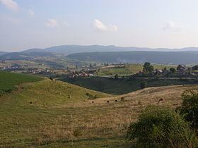
The plateau is actually a large field (Peštersko polje) surrounded by mountains of Jadovnik (1734 m), Zlatar (1627 m), Ozren (1693 m), Giljeva (1617 m), Javor (1519 m), Golija (1833 m), Žilindar (1616 m), Hum (1756 m), Ninaja (1462 m) and Jarut (1428 m). With the area of around 50 km2, Pešter field is the largest field in Serbia, and the highest one in the Balkans. Rivers Uvac, Vapa, Jablanica and Grabovica flow through the plateau. In the geologic past, the field was a large lake, of which only a small Sjenica lake near the village of Tuzinje remained.
The soil is mostly karst interspersed with pastures. Economy of the area relies primarily on cattle breeding, chiefly sheep. Pešter is famous for its dairy products, especially the "Sjenica cheese" (Sjenički sir), as well as lamb and prosciutto. The plateau is sparsely populated: most settlements are on the edge of the field, and the remainder is settled only during summer months.
Pešter is famous for its microclimate, which is particularly harsh in the winter months. The lowest temperature in Serbia since measurements are taken, −39 °C (−38 °F) is measured at Karajukića Bunari village on 26 January 2006, beating the previous record of −38.4 °C (−37.1 °F) measured in Sjenica in 1954.
In the near geological past, the field used to be a highland lake, which gradually drained through karst ruptures, leaving marshy remnants in the lowest parts, around the flow of sinking river Boroštica. Those areas are home to a wet peatbog habitat unique for karst. On 1 May 2006, Ramsar included the wetland area of 3,455 hectares into its list of wetlands of international importance. Pešter is home to a number of endangered species, such as the plants Fumana bonapartei, Halacsya sendtneri and Orchis tridentata. The only nesting place of Montagu's harrier in Serbia is in this area.
Demographics
There is still a small Albanian community speaking the Albanian language in the Pešter region living in villages such as Boroštica, Doliće and Ugao. These Albanians have opted to refer to themselves in censuses as Bosniaks.
A Mosque is being constructed in the region.