
Elevation 1,502 m | Mountain range Dinaric Alps | |
 | ||
Similar Giljeva, Pobijenik, Rogozna, Babička Gora, Seličevica | ||
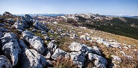
Hum (Serbian Cyrillic: Хум) is a mountain on the border of Serbia and Montenegro, between towns of Sjenica and Rožaje, on the eastern edge of Pešter plateau. Its highest peak Krstača has an elevation of 1,756 meters above sea level.
Map of Krsta%C4%8Da, Serbia
References
Hum (Pešter) Wikipedia(Text) CC BY-SA