
Location Antarctica Max length 2 km | Population 0 | |
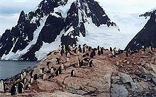 | ||
Antarctica 2010 petermann island
Petermann Island is a small, low and rounded island, lying off the northwest coast of Kiev Peninsula in Graham Land, Antarctica, a short distance south of Booth Island and the Lemaire Channel. It is a popular tourist destination.
Contents
- Antarctica 2010 petermann island
- Map of Petermann Island Antarctica
- Penguin highway on petermann island antarctica
- Description
- Important Bird Area
- History
- References
Map of Petermann Island, Antarctica
Penguin highway on petermann island antarctica
Description
The island is 1.8 km (1.1 mi) long and 1.2 km (0.75 mi) across. It rises steeply to elevations of up to 250 m from a rocky coastline with raised pebble beaches. It has volcanic origins, with about half the land surface covered by a permanent, crevassed icecap. Ice-free areas have a sparse vegetation of mosses and lichens.
Important Bird Area
The island has been identified as an Important Bird Area (IBA) by BirdLife International because it supports a breeding colony of about 3000 pairs of gentoo penguins. Other birds nesting at the site in smaller numbers include Adélie penguins, imperial shags, Wilson's storm petrels and south polar skuas.
History
The island was discovered by a German expedition of 1873-74, who named it after geographer August Petermann. The French Antarctic Expedition of 1908-10 wintered over aboard ship in a cove on the southeast side of the island, named Port Circumcision because it was spotted 1 January 1909, the traditional day for the Feast of the Circumcision.
Huts built by the expedition are gone, although a cairn remains, along with a refuge hut built by Argentina in 1955, and a cross commemorating three members of the British Antarctic Survey who died in a 1982 attempt to cross the sea ice from Faraday Station to Petermann.