
Highest elevation 980 m (3,220 ft) Elevation 980 m | Length 8 km (5 mi) Highest point Wandel Peak | |
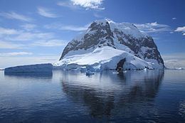 | ||
Port chalcot booth island antarctica february 2016
Booth Island (or Wandel Island) is a rugged, Y-shaped island, 8 kilometres (5 mi) long and rising to 980 m (3,215 ft) off the northwest coast of Kiev Peninsula in Graham Land, Antarctica in the northeastern part of the Wilhelm Archipelago. Booth Island is located at 65°4′48″S 64°0′0″W. Discovered and named by a German expedition under Eduard Dallmann 1873–74, probably for Oskar Booth or Stanley Booth, or both, members of the Hamburg Geographical Society at that time. The Advisory Committee on Antarctic Names has rejected the name "Wandel Island", applied by the Belgian Antarctic Expedition —in honour of Danish polar explorer and hydrographer Carl Frederick Wandel, 1897–99, in favor of the original naming. The narrow passage between the island and the mainland is the scenic Lemaire Channel.
Contents
- Port chalcot booth island antarctica february 2016
- Map of Booth Island Antarctica
- Adelie penguin slide in port charcot booth island antarctica
- References
Map of Booth Island, Antarctica
The highest point of the island is 980-metre (3,215 ft) Wandel Peak. Damien Gildea called it "one of the most challenging unclimbed objectives on the Antarctic Peninsula". On 15 February 2006 the peak was reached by a group of Spanish alpinists, who still avoided the last 10–15 metres (32.8–49.2 ft) of the mushroomlike top.