
Catchment area 9,713 km (3,750 sq mi) Surface area 552 km (213 sq mi) Surface elevation 421 m | Area 1,434 km² | |
 | ||
Primary inflows Outflow location Churchill River, Churchill Lake | ||
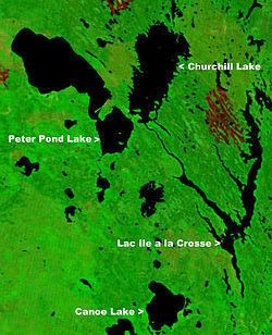
Peter Pond Lake is a glacial lake in Saskatchewan, Canada. It is located in northwestern Saskatchewan in the Boreal Forest and Canadian Shield within the Churchill River drainage basin. It was on the fur trade route to the Methye Portage which connected eastern Canada to the MacKenzie River area. The lake is a long oval tending to the northwest. A peninsula which almost reaches the west shore divides it into Big Peter Pond (the northern two thirds) and Little Peter Pond. On the west side of Little Peter Pond a narrow isthmus separates it from Churchill Lake, the two forming a broad "V". The La Loche River, which drains Lac La Loche comes in from the north while the Dillon River, with the village of Dillon at its mouth, comes in from the west. The lake drains into Churchill Lake through the Kisis Channel at Buffalo Narrows, Saskatchewan. Originally called Big and Little Buffalo Lakes, it was renamed after Peter Pond in 1931. It is on Highway 155 which passes through Buffalo Narrows.
Contents
Map of Peter Pond Lake, Saskatchewan, Canada
Fish Species
The lake's fish species include: walleye, sauger, yellow perch, northern pike, lake trout, lake whitefish, cisco, white sucker, longnose sucker and burbot.