
Country United States of America | ||
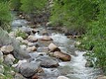 | ||
Peteetneet Creek is a stream named after the Timpanogos Chief Peteetneet who lived near it, in the vicinity of what is now Payson, Utah. Its source is located at 39°56′52″N 111°40′37″W, the confluence of Shram Creek and Frank Young Canyon Creek.
Contents
Map of Peteetneet Creek, Payson, UT, USA
History
Peteneet Creek was a good camping spot on the Mormon Road, a Mormon pioneer and 49er wagon route between Salt Lake City and Los Angeles. The Latter-day Saints first settled in Payson in 1850. After improvements were made to the Mormon Road wagon route in 1855, it had become what was known as the Los Angeles - Salt Lake Road. This was a wagon freight route used each year from late fall through winter into early spring, between Southern California and Utah, isolated by the winter snows in the Sierra Nevada Mountains from San Francisco and by the Rocky Mountains from the rest of the United States to the east. This route remained the only winter season route to the outside world, until the arrival of the railroad in Utah in the late 1860s.