
Country Canada County Renfrew Time zone EST (UTC-5) Population 15,988 (2011) | Incorporated (town) July 1, 1997 Local time Monday 6:26 PM | |
 | ||
Weather 3°C, Wind E at 6 km/h, 94% Humidity Points of interest Garrison Petawawa, Petawawa Centennial Park, Petawawa Heritage Village | ||
Petawawa is a town located in eastern portion of Southern Ontario. Situated in the Ottawa Valley, with a population of 15,988 (2011 Census). Petawawa is the most populous municipality in Renfrew County.
Contents
- Map of Petawawa ON Canada
- Geography
- Transportation
- Primary industries
- History
- Climate
- Communities
- Notable Residents
- References
Map of Petawawa, ON, Canada
Geography
Petawawa is located at latitude 45°54' north and longitude 77°17' west.
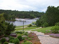
The town lies on the west bank of the Ottawa River, at the confluence of the Petawawa River. Situated across the Ottawa River from the Laurentian Mountains, and east of Algonquin Park, Petawawa is a favourite stop for outdoor enthusiasts, anglers, hikers, canoers, and kayakers.
Transportation
Ontario Highway 17, Greyhound bus lines, Ontario Northlands bus service from Ottawa and the local commercial airport (Pembroke Airport) located in Petawawa, all provide access to this town.
Primary industries
Petawawa's primary employer is the Canadian Government. Most of Petawawa's residents work as civilian employees, or as members of the Canadian Forces at CFB Petawawa which is home to 2 Canadian Mechanized Brigade Group, and 4 Canadian Division Support Group
Another major employer is Atomic Energy of Canada Limited located nearby in Chalk River.
History
The earliest settlement in the Petawawa area was inhabited by the Algonquin First Nation. The name of Petawawa originates from a local Algonquin language word, biidaawewe, meaning "where one hears a noise like this". The spelling of the name of the town was Petewawa until at least 1916. There are no sources showing when the official name was changed from Petewawa to Petawawa, but photographs after 1916 with the former spelling have not been found. While the records of the official name change are non-existent, it has been speculated that the influx of immigration to the area changed the pronunciation of the word from its native roots to a more European pronunciation. Over time this may have changed the spelling of the Town's name into the present day format.
In the late 19th century, the area was surveyed and settled by emigres from Scotland, Ireland and Germany. The land was unsuitable for crops, but the heavily forested surroundings were useful for logging. The Canadian military acquired land in the area in 1905, which later became Canadian Forces Base Petawawa. During this period it was used as an internment camp for German POWs during World War II. Later, it became home to the Canadian Airborne Regiment before it was disbanded in 1995. Today, it is one of Canada's largest ground forces bases with members deployed throughout the world on various missions supporting the United Nations in peacekeeping or the War on Terror.
Petawawa was incorporated as a township in 1865. An Internment camp was set up at the Militia Camp in Petawawa from December 1914 to May 1916.
In 1961, the urban area of Petawawa was incorporated as a separate village. On July 1, 1997, the village and township re-amalgamated to form the Town of Petawawa.
Climate
Petawawa has a humid continental climate (Köppen Dfb) with long, cold, snowy winters and warm summers.
Communities
In addition to the primary urban core of Petawawa, the town also comprises the communities of Black Bay, Kramer Subdivision, Laurentian View, McGuire, Petawawa Point, Pine Meadows, Pine Ridge, Pinehurst Estates and Riverview.
Notable Residents
Entertainers
Sports