
Time zone EET (UTC+2) Vehicle registration ΚΜ Area code 27220 | Elevation 21 m (69 ft) Postal code 240 05 Local time Tuesday 12:41 AM | |
 | ||
Weather 11°C, Wind W at 0 km/h, 73% Humidity | ||
petalidi messenia greece 4k uhd
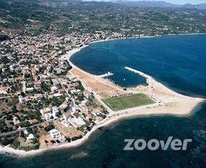
Petalidi (Greek: Πεταλίδι) is a village and a former municipality in Messenia, Peloponnese, Greece. Since the 2011 local government reform it is part of the municipality Messini, of which it is a municipal unit. The municipal unit has an area of 104.970 km2. Petalidi is situated on the western shore of the Messenian Gulf, 13 km southwest of Messini, 18 km southwest of Kalamata and 21 km east of Pylos. The road Greek National Road 82 (Pylos - Kalamata) passes through the north of the municipal unit.
Contents
- petalidi messenia greece 4k uhd
- Map of Petalidi Greece
- Paramotor petalidi greece 2
- Subdivisions
- References
Map of Petalidi, Greece
Paramotor petalidi greece 2
Subdivisions
The municipal unit Petalidi is subdivided into the following communities (2011 population in brackets):
References
Petalidi Wikipedia(Text) CC BY-SA