
Type Foreland Basin Thickness 12 to 13 Km | Area 93,000 square miles | |
 | ||
Country | ||
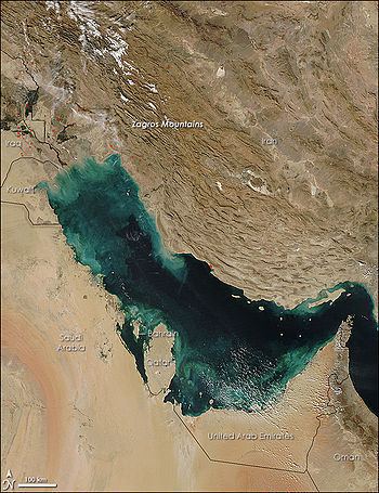
The Persian Gulf Basin, is found between the Eurasian and the Arabian Plates. The Persian Gulf is described as a shallow marginal sea of the Indian Ocean that is located between the south western side of Iran and the Arabian Peninsula and south and southeastern side of Oman and the United Arab Emirates. Other countries that border the Persian Gulf basin include; Saudi Arabia, Qatar, Kuwait, Bahrain and Iraq. The Gulf extends a distance of 1000 km with an area of 240,000 square km. The Persian Gulf basin is a wedge-shaped foreland basin which lies beneath the western Zagros thrust and was created as a result of the collision between the Arabian and Eurasian plates.
Contents
Persian Gulf Basin and the Middle East
A collection of these countries is commonly referred to as the Middle East which is the oil-rich location in the south western side of the Asia continent. A review of the world’s energy with different estimates indicates that the Middle East holds 55% to 68% of the world’s oil deposits and more than 40% of the world’s recoverable natural gas reserves.
Worldwide, it’s the richest side of the world in terms of hydrocarbon resources, both oil and gas reserves with an area of approximately 93000 square miles. The name Persian Gulf in most cases refers not only to the Persian Gulf but also the Gulf of Oman, the Strait of Hormuz and various outlets that are linked to the Arabian Sea.
Tectonic evolution
The Arabian Plate tectonic origin is grouped into six phases which contributed to its current geology:
The Precambrian phase
The early Precambrian (from 800 to 650 Ma) is a compressional phase where a series of islands-arcs and micro-continent terrane accreted to form the oldest portions of the Arabian Plate (Gondwana). The development of Hormuz saltbasin was a consequence of the last Precambrian orogenic event.
The Ordovician-Silurian glaciations
An expanding of polar glaciation in Gondwana occurred in the Late Ordovician, and later sea level rose in the Early Silurian was as a result of the deglaciation which led to extensive deposition of organic-rich shale that corresponds to a maximum flooding surface. This hot shale is considered the major source of Paleozoic hydrocarbon in Saudi Arabia.
The Carboniferous phase
During the Late Devonian, the plate was located in a back-arc-setting. The initiation of the Hercynian Orogeny led to the uplift of the central Arabian plate and tilted it eastward, which resulted in a basement tectonism and extensive erosion. The Arabian Plate underwent many compressional phases during this period.
The early Triassic
Thermal subsidence and Arabian plate stretching (that resulted from the fragmentation of Gondwana in the Late Permian) resulted in extensional faulting and the early rifting of Zagros that opened the Neo-Tethys Sea.
Late Cretaceous phase (Early Alpine Orogeny)
This period was where the Alpine Orogeny started to form as a result of compression, which resulted in major uplifts and erosions, in addition to the closure of Neo-Tethys Sea.
The Tertiary phase (The Late Alpine Orogeny)
During this period there was the second Alpine Orogeny, which was as a result of the collision the Arabian and the Eurasian plates at the Mesozoic and Cenozoic border and this resulted in the formation of the Zagros Fold Belt together with the extensive Mesopotamian Foredeep and thus the formation of the foreland Persian basin. In addition to the opening of the Red Sea about ~25 Ma, which resulted in the separation of the African and the Arabian plates.
Structural and tectonic settings
The Arabian Plate shows divergent margins around the adjacent areas of the Gulf of Aden, Red Sea and the south western side of the Arabian plate. On the south and south eastern side of the Arabian plate lies the Owen-Sheba which is an intra-oceanic transform fault. Then there is convergent margin located on the north and north eastern side close to Turkey and in the Zagros Mountains located on the east of Iran, where the Arabian plate is subducting underneath the Eurasian plate. Lastly the Dead Sea, which is a transform fault zone found on the north western side of the Arabian plate.
The current deformation and accumulation processes that are related to the natural structures and the subsequent compression of the layers within the Persian Gulf illustrates the origin of the various natural resources found in the place, the geologic processes and the tectonic regimes that occurred.
The tectonic representation of the Middle East is divided into three parts that have different characteristics concerning their age, thickness and types of rocks :
The end of the Paleozoic experienced some transformations in terms of subsidence differentiations and seal level rise that led to the formation of structural elements such as the three troughs:
Which is located in the middle part of the basin which is largely covered by Saudi Arabia and Bahrain.
Which is in the northern side of the basin covering Iraq and Syria.
Which is found in the Saudi Arabia and parts of United Arab Emirates.
Most of the geological characteristics were established during the Paleozoic which were initiated by the continuous continental marine sedimentation on the north east side of Gondwana. Some complex events which were effects of the carboniferous processes also affected the area through creation of regional uplift, extensive erosions some basement tectonics. Therefore, the consistent tectonic geological evolution and the structural settings that resulted thereafter formed the Arabian plate after successive tectonic regimes.